The National Geologic Map Database is migrating to a new infrastructure. We apologize for any service disruptions during this process.
|
|---|


- Usage in publication:
-
- Keller Creek Shale*
- Modifications:
-
- Named
- Dominant lithology:
-
- Graywacke
- Shale
- Siltstone
- AAPG geologic province:
-
- Blue Mountains province
- Columbia basin
Summary:
Keller Creek Shale, uppermost formation of Aldrich Mountains Group (new). Lower 2,000 to 2,500 feet consists of massive to well-bedded, coarse- to fine-grained, tuffaceous graywacke, in which there are lenses of pebbly conglomerate, subordinate amounts of shale, and few thin ashy beds. In middle and upper parts of formation, gray to black shale interbedded with graywacke and siltstone in beds a few inches thick is dominant; near top is massive coarse- to fine-grained graywacke 500 to 1,000 feet thick. Thickness about 5,000 feet at type locality. Elsewhere, formation consists mostly of medium-bedded shale and siltstone. Essentially conformable with underlying Murderers Creek Graywacke (new) of Aldrich Mountains Group. Marked angular unconformity separates the Keller Creek from overlying Lower Jurassic rocks. Age is Early Jurassic.
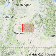
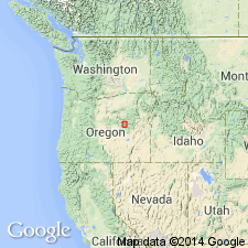
Type locality: exposures near headwaters of Keller Creek, northwest corner of Logdell 15-min quadrangle, Grant Co., northeastern OR. Named from Keller Creek.
Source: US geologic names lexicon (USGS Bull. 1350, p. 385); supplemental information from GNU records (USGS DDS-6; Menlo GNULEX).
- Usage in publication:
-
- Keller Creek Shale*
- Modifications:
-
- Overview
- AAPG geologic province:
-
- Blue Mountains province
Summary:
Pg. A27, A29 (fig. 4). Keller Creek Shale. Consists mainly of medium-bedded mudstone, shale, siltstone, massive volcanic graywacke, and waterlaid tuff; contains thin lenses of limestone breccia and cobbly mudstone in northern part of Izee quadrangle. Best exposed in headwaters of Keller Creek, northwest corner of Logdell quadrangle, northeastern Oregon. Is about 5,000 feet thick at type locality. Lower 2,000 to 2,500 feet consists of massive to well-bedded, coarse- to fine-grained tuffaceous graywacke, in which there are lenses of pebbly conglomerate, subordinate shale, and a few thin zeolitized (laumontite) ashy beds. Middle and upper parts consist dominantly of gray to black shale interbedded with graywacke and siltstone in beds 1 inch to 1 or 2 feet thick; massive coarse- to fine-grained graywacke 500 to 1,000 feet thick occurs near top. Generally conformably overlies Murderers Creek Graywacke; there is some evidence of local erosion. A marked angular unconformity separates Keller Creek from overlying Lower Jurassic rocks. Shales in upper part of formation yielded ARNIOCERAS of early Sinemurian age and CRUCILOBICERAS and GLEVICERAS of late Sinemurian age (citing R.W. Imlay, written commun., 1965). Age is Early Jurassic.
Source: Publication.
For more information, please contact Nancy Stamm, Geologic Names Committee Secretary.
Asterisk (*) indicates published by U.S. Geological Survey authors.
"No current usage" (†) implies that a name has been abandoned or has fallen into disuse. Former usage and, if known, replacement name given in parentheses ( ).
Slash (/) indicates name conflicts with nomenclatural guidelines (CSN, 1933; ACSN, 1961, 1970; NACSN, 1983, 2005, 2021). May be explained within brackets ([ ]).