

- Usage in publication:
-
- Kayak shale*
- Modifications:
-
- Named
- Biostratigraphic dating
- Dominant lithology:
-
- Sandstone
- Shale
- Limestone
- AAPG geologic province:
-
- Alaska Northern region
Summary:
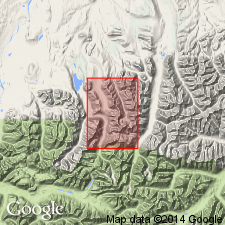
Shown on preliminary geologic map of Shainin Lake area. Kayak shale and Kanayut conglomerate (new) comprise rocks previously referred to as Noatak formation (Smith and Mertie, 1930; and Payne and others, 1952). At type locality, composed of five unnamed units (ascending): sandstone 130 feet thick; lower black shale, 595 feet thick; argillaceous limestone 80 feet thick; upper black shale, 140 feet thick and red limestone 10-15 feet thick. Total thickness 960 feet (292 m). Disconformably underlies Wachsmuth limestone (new). Disconformably overlies Kanayut conglomerate (new). Age is Early Mississippian, based on coral-echinoderm-bryozoan-brachiopod faunas in upper part of formation. Three faunal zones are recognized: SCALRITUBA (Shiner and Shrock, 1944) restricted to basal sandstone; LEPTAENA ANALOGA (Cooper, 1944) in argillaceous limestone and upper black shale; and CYRPTOBLASTUS aff. C. PISUM (Cline, 1944) in red limestone.
Type section: exposures in saddle on south side of Mount Wachsmuth, 1.8 mi east of Shainin Lake area, Lat. 68 deg. 19 min. 19 sec. N., Long. 150 deg. 54 min. 29 sec. W., central Brooks Range AK. Named for Kayak Creek which joins Alapah Creek south of Shainin Lake.
Source: Modified from GNU records (USGS DDS-6; Menlo GNULEX).
- Usage in publication:
-
- Kayak Shale*
- Modifications:
-
- Revised
- AAPG geologic province:
-
- Alaska Northern region
Summary:
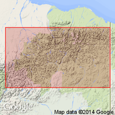
Occurs beneath Lisburne Group throughout eastern and central Brooks Range. In type area and throughout central Brooks Range, disconformably overlies Kanayut Conglomerate. Disconformably underlies Wachsmuth Limestone. On the east, overlies Kanayut Conglomerate in southeastern part of range and Neruokpuk Formation at Echooka River. East of Canning River, a similar black shale unit along north front of range is questionably correlated with type Kayak Shale and designated Kayak(?) Shale. Kayak(?) overlies Kekiktuk Conglomerate and Neruokpuk Formation, and underlies Alapah Limestone. Kayak Shale is Early Mississippian age. Kayak(?) Shale is Early(?) and Late Mississippian age.
Source: GNU records (USGS DDS-6; Menlo GNULEX).
- Usage in publication:
-
- Kayak shale*
- Modifications:
-
- Areal extent
- AAPG geologic province:
-
- Alaska Northern region
Summary:
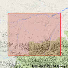
Occurs in Killik-Etivluk region at Howard Pass, Killik Valley and Otuk Creek, western Brooks Range, AK. Underlies Wachsmuth limestone. Overlies Kanayut conglomerate. Age is Early Mississippian.
Source: GNU records (USGS DDS-6; Menlo GNULEX).

- Usage in publication:
-
- Kayak Shale*
- Modifications:
-
- Revised
- AAPG geologic province:
-
- Alaska Northern region
Summary:
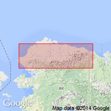
Assigned to Endicott Group (new) as uppermost of five formations. Composed of dark colored shale with a quartz sandstone interval at base and limestone and shale intervals at top. Thickness generally less than 300 m. Overlies Kanayut Conglomerate (Endicott Group) in central Brooks Range and locally overlies Noatak Sandstone (Endicott Group) in Baird Mountains of western Brooks Range. Underlies Mississippian carbonate rocks of Lisburne Group. Kayak(?) Shale of northeastern Brooks range is like type Kayak Shale in thickness, lithology, and stratigraphic position, but is generally younger. Kayak Shale is Early Mississippian age. Kayak(?) Shale is Early(?) and Late Mississippian. "Shales characteristic of Kayak Shale transgress Lower and Upper Mississippian Series".
Source: GNU records (USGS DDS-6; Menlo GNULEX).
- Usage in publication:
-
- Kayak Shale*
- Modifications:
-
- Biostratigraphic dating
- AAPG geologic province:
-
- Alaska Northern region
Summary:
Age is considered Early Mississippian in central Brooks Range based on revised megafossil zonations. Noted fossils are plants, brachiopods, bryozoans, echinoderms, goniatites, and trace fossils SCALARITUBA and SKOLITHOS. Assemblages range from Kinderhookian to Osagean in age as shown on correlation chart. Kayak(?) Shale is Meramecian to Chesterian.
Source: GNU records (USGS DDS-6; Menlo GNULEX).
For more information, please contact Nancy Stamm, Geologic Names Committee Secretary.
Asterisk (*) indicates published by U.S. Geological Survey authors.
"No current usage" (†) implies that a name has been abandoned or has fallen into disuse. Former usage and, if known, replacement name given in parentheses ( ).
Slash (/) indicates name conflicts with nomenclatural guidelines (CSN, 1933; ACSN, 1961, 1970; NACSN, 1983, 2005, 2021). May be explained within brackets ([ ]).