

- Usage in publication:
-
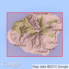
- Kauai lavas
- Modifications:
-
- Named
- Dominant lithology:
-
- Basalt
- AAPG geologic province:
-
- Kauai
Hinds, N.E.A., 1930, Geology of Kauai and Niihau: Bernice P. Bishop Museum Bulletin, no. 71, 103 p.
Summary:
Basaltic lava flows distributed over most of Island of Kauai, Hawaiian Islands. No type locality designated but Waimea conglomerate (new) separates lower Kauai lavas from upper Kauai lavas in Waimea Canyon. Upper Kauai is as much as 4000 ft thick. Unconformably underlies lavas of Koloa volcanic episode. [named for Island of Kauai]
Source: GNU records (USGS DDS-6; Menlo GNULEX).
- Usage in publication:
-
- Kauai lavas
- Modifications:
-
- Age modified
- Not used
- AAPG geologic province:
-
- Kauai
Summary:
"Included in what is now known as the Waimea Canyon volcanic series, which see." Assigned Pliocene(?) age.
Source: GNU records (USGS DDS-6; Menlo GNULEX).
For more information, please contact Nancy Stamm, Geologic Names Committee Secretary.
Asterisk (*) indicates published by U.S. Geological Survey authors.
"No current usage" (†) implies that a name has been abandoned or has fallen into disuse. Former usage and, if known, replacement name given in parentheses ( ).
Slash (/) indicates name conflicts with nomenclatural guidelines (CSN, 1933; ACSN, 1961, 1970; NACSN, 1983, 2005, 2021). May be explained within brackets ([ ]).