The National Geologic Map Database is migrating to a new infrastructure. We apologize for any service disruptions during this process.
|
|---|


- Usage in publication:
-
- Katolinat Conglomerate Member*
- Modifications:
-
- Named
- Biostratigraphic dating
- Dominant lithology:
-
- Conglomerate
- AAPG geologic province:
-
- Alaska Peninsula province
- Alaska Southwestern region
Summary:
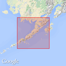
Katolinat Conglomerate Member of Naknek Formation. Name applied to uppermost member (of 5) on Alaska Peninsula, southwestern Alaska. Exposed for about 100 km in Mount Katmai quadrangle (scale 1:250,000) and over a few sq km in area between Wide Bay and Imuya Bay. Composed of conglomerate and coarse-grained sandstone beds. Conformably overlies Indecision Creek Sandstone Member (new) of Naknek Formation. Locally disconformably underlies Herendeen Formation. Age is Late Jurassic (Tithonian) based on BUCHIA fossils.
Type section: exposures on unnamed mountain on northeast shore of Grosvenor Lake, in secs. 33 and 34, T. 17 S., R. 35 W., Mount Katmai C-4 quadrangle (1:63,360), Alaska Peninsula, southwestern AK. Named from exposures on Mount Katolinat, Mount Katmai B-5 quadrangle.
Source: Modified from GNU records (USGS DDS-6; Menlo GNULEX).
For more information, please contact Nancy Stamm, Geologic Names Committee Secretary.
Asterisk (*) indicates published by U.S. Geological Survey authors.
"No current usage" (†) implies that a name has been abandoned or has fallen into disuse. Former usage and, if known, replacement name given in parentheses ( ).
Slash (/) indicates name conflicts with nomenclatural guidelines (CSN, 1933; ACSN, 1961, 1970; NACSN, 1983, 2005, 2021). May be explained within brackets ([ ]).