

- Usage in publication:
-
- Katlian Group*
- Modifications:
-
- Named
- Dominant lithology:
-
- Phyllite
- Metavolcaniclastics
- AAPG geologic province:
-
- Alaska Southeastern region
Summary:
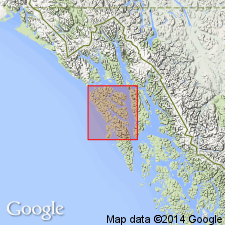
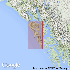
[Presumably named for Mt. Katlian on southwestern Chichagof Island.] Type locality is designated as Mt. Katlian on Baranof Island (Sitka 1:250,000 quad), southeastern AK. Consists of phyllite, greenschist, and semischist with minor metachert and greenstone; also some graywacke and serpentinite. Lower contact not observed; upper contact with Kelp Bay Group appears to be transitional. Age is regarded as Permian(?) and Triassic(?) based on regional stratigraphic correlations.
Source: GNU records (USGS DDS-6; Menlo GNULEX).
- Usage in publication:
-
- Katlian Group†
- Modifications:
-
- Abandoned
- AAPG geologic province:
-
- Alaska Southeastern region
Summary:
Unit is abandoned. Its rocks are reassigned to the Kelp Bay Group.
Source: GNU records (USGS DDS-6; Menlo GNULEX).
For more information, please contact Nancy Stamm, Geologic Names Committee Secretary.
Asterisk (*) indicates published by U.S. Geological Survey authors.
"No current usage" (†) implies that a name has been abandoned or has fallen into disuse. Former usage and, if known, replacement name given in parentheses ( ).
Slash (/) indicates name conflicts with nomenclatural guidelines (CSN, 1933; ACSN, 1961, 1970; NACSN, 1983, 2005, 2021). May be explained within brackets ([ ]).