

- Usage in publication:
-
- Karla Kay conglomerate member*
- Modifications:
-
- Named
- Dominant lithology:
-
- Conglomerate
- Sandstone
- AAPG geologic province:
-
- Paradox basin
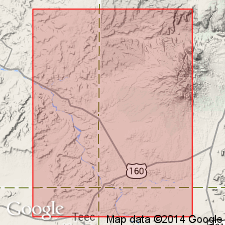
Summary:
Named as the basal member of Burro Canyon formation for exposure at Karla Kay mine in McElmo Canyon, Montezuma Co, CO, Paradox basin. No type locality designated though a section measured at Tozer Gulch, a tributary of McElmo Canyon, sec 30, T36N, R18W identifies member as a 64 ft thick conglomerate of tan-gray to grayish-green, weathers dark brown and black, firmly cemented pebbles 1/2 to 2 1/2 in diameter of subround chert in a matrix of coarse-grained clayey sandstone. Has festoon-type cross beds, troughs plunge east. Forms massive cliff with knobby surface due to pebbles. Dinosaur bones and silicified trees. Occurs at Tozer Gulch as nonpersistent lenses 600 ft wide. Section 22 ft thick recognized as Karla Kay measured at Hatch's Trading Post 109 deg 13'45" Long, 37 deg 23'30" Lat. Overlies Brushy Basin Member of Morrison formation, a contact considered conformable to intertonguing. Underlies unnamed part of Burro Canyon. Occurs as thin discontinuous lenses. Channels rarely more than 2,000 ft wide or more than 65 ft thick. Represents a new sedimentary cycle initiated by uplift west of Four Corners area. Source to west. May be equivalent to Buckhorn conglomerate member of Cedar Mountain formation. Early Cretaceous age. Cross section.
Source: GNU records (USGS DDS-6; Denver GNULEX).
- Usage in publication:
-
- Karla Kay Conglomerate Member*
- Modifications:
-
- Overview
- AAPG geologic province:
-
- Paradox basin
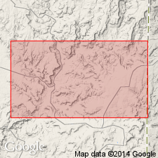
Summary:
Occurs as shoestring lenses and assigned to basal part, Burro Canyon Formation. Recently discovered fossil fresh water mollusks found in the Karla Kay Conglomerate Member at two localities: 1) sec 29, T38S, R24E, San Juan Co, UT; and 2) sec 27, T36N, R20W, Montezuma Co, CO indicate a Cretaceous age for the member. Fossil plant, a rhizome or rootstock of a large monocotyledonous plant also found at the UT locality not known from rocks older than Early Cretaceous. Karla Kay is not considered a channel deposit of the upper part of the Morrison Formation. Karla Kay is a series of shoestring lenses found locally at base of Burro Canyon Formation in southeast UT and southwest CO in the Paradox basin.
Source: GNU records (USGS DDS-6; Denver GNULEX).
- Usage in publication:
-
- Karla Kay Member*
- Modifications:
-
- Overview
- AAPG geologic province:
-
- Paradox basin
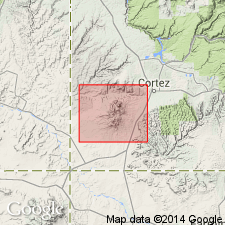
Summary:
Is part of a system of shoestring lenses or channel-fillings of conglomerate and conglomeratic sandstone. Highly resistant to weathering. Forms vertical cliffs and knobby outcrops. Channel fillings have been undercut in many areas and their former locations marked by huge blocks-some as large as a house-that have slumped down into the underlying mudstone. Mapped in northern part of Ute Mountains area, Montezuma Co, CO, Paradox basin.
Source: GNU records (USGS DDS-6; Denver GNULEX).
For more information, please contact Nancy Stamm, Geologic Names Committee Secretary.
Asterisk (*) indicates published by U.S. Geological Survey authors.
"No current usage" (†) implies that a name has been abandoned or has fallen into disuse. Former usage and, if known, replacement name given in parentheses ( ).
Slash (/) indicates name conflicts with nomenclatural guidelines (CSN, 1933; ACSN, 1961, 1970; NACSN, 1983, 2005, 2021). May be explained within brackets ([ ]).