The National Geologic Map Database is migrating to a new infrastructure. We apologize for any service disruptions during this process.
|
|---|


- Usage in publication:
-
- Kanab Canyon member
- Modifications:
-
- Original reference
- Dominant lithology:
-
- Limestone
- Siltstone
- Sandstone
- AAPG geologic province:
-
- Plateau sedimentary province
Summary:
Pg. 14 (fig. 1), 29, 102-105. Kanab Canyon member of Muav formation of Tonto group. Changes in lithology considerably from east to west. At type locality consists of single massive cliff of uniform lithology composed of mottled limestone; 25 miles to southeast at Bass trail it includes sandy shale in basal 10 feet, and 8 miles farther in the same direction, it is divisible, on basis of lithology, into two parts of about equal thickness. Thickness increases westward and northward as far as Granite Park, and ranges from 62 to 143 feet. Conformably [paraconformity?] underlies Gateway Canyon member (new) and overlies Peach Springs member (new), west of Fossil Rapids. East of Fossil Rapids, conformably overlies Bright Angel shale. Called subdivision C of Tonto group by Walcott. Fossils indeterminate; limestone carries numerous burrows and trails. Age is Middle Cambrian, based on stratigraphic position. Report includes cross sections, measured sections.
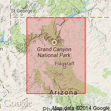
Type locality: at the mouth of Kanab Canyon, where it is lowest massive cliff-forming unit, not far above level of Colorado River. Lowest subdivision of Muav formation throughout eastern part of Grand Canyon, [Kanab Point 15-min quadrangle], Mohave and Coconino Cos., northwestern AZ.
Source: US geologic names lexicon (USGS Bull. 1200, p. 1963); supplemental information from GNU records (USGS DDS-6; Menlo GNULEX, Denver GNULEX), GNC index card files.
For more information, please contact Nancy Stamm, Geologic Names Committee Secretary.
Asterisk (*) indicates published by U.S. Geological Survey authors.
"No current usage" (†) implies that a name has been abandoned or has fallen into disuse. Former usage and, if known, replacement name given in parentheses ( ).
Slash (/) indicates name conflicts with nomenclatural guidelines (CSN, 1933; ACSN, 1961, 1970; NACSN, 1983, 2005, 2021). May be explained within brackets ([ ]).