The National Geologic Map Database is migrating to a new infrastructure. We apologize for any service disruptions during this process.
|
|---|


- Usage in publication:
-
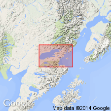
- Kakhonak Complex*
- Modifications:
-
- Named
- Dominant lithology:
-
- Argillite
- Schist
- Quartzite
- AAPG geologic province:
-
- Alaska Peninsula province
- Alaska Southwestern region
Summary:
Named for Kakhonak Lake, River, and Bay. Type locality designated as exposures along Kakhonak Lake southeast of Iliamna Lake, Iliamna quad, Alaska Peninsula, AK. Consists of metamorphic rocks mainly of greenschist facies, including argillite, schist, and quartzite; locally of pyroxene-hornfels, amphibolite, and granulite facies. Is over 1000 m thick. Forms roof pendants in Alaska-Aleutian Range batholith. Is complexly faulted and folded. Locally, apparently conformably, overlies Cottonwood Bay Greenstone; interbedded with and overlain by metavolcanic rocks; intruded by Jurassic rocks of Alaska-Aleutian Range batholith. Is Permian(?), Triassic, and Jurassic age.
Source: GNU records (USGS DDS-6; Menlo GNULEX).
- Usage in publication:
-
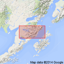
- Kakhonak Complex*
- Modifications:
-
- Age modified
- AAPG geologic province:
-
- Alaska Peninsula province
- Alaska Southwestern region
Summary:
Age of the Kakhonak Complex is Paleozoic(?), Triassic, and Jurassic based on regional stratigraphic relationships (uncertainty of unit's protolith ages).
Source: GNU records (USGS DDS-6; Menlo GNULEX).
For more information, please contact Nancy Stamm, Geologic Names Committee Secretary.
Asterisk (*) indicates published by U.S. Geological Survey authors.
"No current usage" (†) implies that a name has been abandoned or has fallen into disuse. Former usage and, if known, replacement name given in parentheses ( ).
Slash (/) indicates name conflicts with nomenclatural guidelines (CSN, 1933; ACSN, 1961, 1970; NACSN, 1983, 2005, 2021). May be explained within brackets ([ ]).