

- Usage in publication:
-
- Kachess rhyolite*
- Modifications:
-
- Named
- Dominant lithology:
-
- Rhyolite
- AAPG geologic province:
-
- Cascades province
Summary:
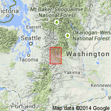
Unit is named the Kachess rhyolite, for Kachess Lake, [Kachess Lake 7.5' quad] Kittitas Co., WA. Consists of several thick flows of white or yellow acidic lava. Throughout a large part of its extent it is separated by interbedded sandstones and basalts into several distinct rhyolitic sheets. Elsewhere these sheets merge together, and cannot be distinguished as separate units. Maximum thickness is 4,000 ft. Conformably overlies and in places is interbedded with the Naches formation (new); Conformably underlies the Teanaway basalt. Age is Eocene.
Source: GNU records (USGS DDS-6; Menlo GNULEX).
- Usage in publication:
-
- Kachess Rhyolite†
- Modifications:
-
- Abandoned
- AAPG geologic province:
-
- Cascades province
Summary:
Kachess Rhyolite is abandoned. Rocks previously assigned to the Kachess are reassigned to the Silver Pass Volcanic Member (new) of the Swauk Formation.
Source: GNU records (USGS DDS-6; Menlo GNULEX).
For more information, please contact Nancy Stamm, Geologic Names Committee Secretary.
Asterisk (*) indicates published by U.S. Geological Survey authors.
"No current usage" (†) implies that a name has been abandoned or has fallen into disuse. Former usage and, if known, replacement name given in parentheses ( ).
Slash (/) indicates name conflicts with nomenclatural guidelines (CSN, 1933; ACSN, 1961, 1970; NACSN, 1983, 2005, 2021). May be explained within brackets ([ ]).