

- Usage in publication:
-
- Joy Tuff*
- Modifications:
-
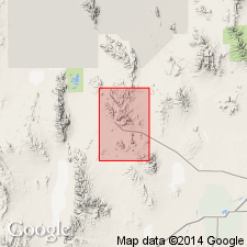
- Named
- Reference
- Dominant lithology:
-
- Tuff
- AAPG geologic province:
-
- Great Basin province
Summary:
Named for exposures northwest of Joy townsite. Type locality is in secs 16, 17, and 22, T14S, R11W, Juab Co, UT, Great Basin province. Reference section is in secs 25 and 36, T13S, R11W. Divided into crystal tuff member (base) and upper black glass tuff member (top). Crystal member is gray-pink to red-brown rhyolitic ash-flow tuff with abundant crystals of quartz, sanidine, plagioclase, and biotite in a moderately welded matrix of devitrified shards. Black glass tuff member is gray to black rhyolitic ash-flow tuff with sparse crystals of sanidine, quartz, plagioclase, and biotite and lithic fragments of limestone and volcanic rocks. Is younger than Mt. Laird Tuff (new) and older than an Oligocene? landslide breccia. Is 210 m thick. Assigned a late Eocene and early Oligocene age. Basal member yielded an average age of 38.0 +/-0.7 m.y. from 8 F-T ages that ranged from 34.5 +/-1.3 m.y. to 40.0 m.y.
Source: GNU records (USGS DDS-6; Denver GNULEX).
- Usage in publication:
-
- Joy Tuff*
- Modifications:
-
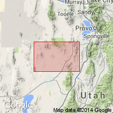
- Areal extent
- AAPG geologic province:
-
- Great Basin province
Summary:
Joy Tuff is geographically extended into the Picture Rock Hills and Keg Mountains. Age is late Eocene and early Oligocene.
Source: GNU records (USGS DDS-6; Menlo GNULEX).
For more information, please contact Nancy Stamm, Geologic Names Committee Secretary.
Asterisk (*) indicates published by U.S. Geological Survey authors.
"No current usage" (†) implies that a name has been abandoned or has fallen into disuse. Former usage and, if known, replacement name given in parentheses ( ).
Slash (/) indicates name conflicts with nomenclatural guidelines (CSN, 1933; ACSN, 1961, 1970; NACSN, 1983, 2005, 2021). May be explained within brackets ([ ]).