The National Geologic Map Database is migrating to a new infrastructure. We apologize for any service disruptions during this process.
|
|---|


- Usage in publication:
-
- Jones Falls Schist
- Modifications:
-
- Named
- Dominant lithology:
-
- Schist
- AAPG geologic province:
-
- Piedmont-Blue Ridge province
Summary:
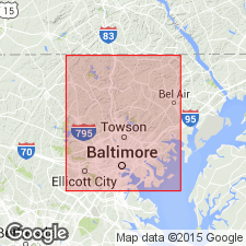
Name Jones Falls Schist proposed for outcrops of medium- to coarse-grained biotite-plagioclase-muscovite-quartz schist along Jones Falls, just east of Druid Hill Park, Baltimore City, MD. In places, schist is accompanied by fine-grained biotite-plagioclase-quartz gneiss in layers a few cm thick. Garnet and tourmaline are accessory minerals in some outcrops. Jones Falls also includes very minor muscovite-plagioclase-quartz schist, quartzite, amphibolite, and muscovite-quartz-feldspar gneiss. Thickness ranges from 0 to 250 m. Overlies the Relay Gneiss, Carroll Gneiss, or Druid Hill Amphibolite Members (all new) of the James Run Formation in the Laurel belt, a northeast-southwest syncline. Age is shown as Cambrian(?).
Source: GNU records (USGS DDS-6; Reston GNULEX).
For more information, please contact Nancy Stamm, Geologic Names Committee Secretary.
Asterisk (*) indicates published by U.S. Geological Survey authors.
"No current usage" (†) implies that a name has been abandoned or has fallen into disuse. Former usage and, if known, replacement name given in parentheses ( ).
Slash (/) indicates name conflicts with nomenclatural guidelines (CSN, 1933; ACSN, 1961, 1970; NACSN, 1983, 2005, 2021). May be explained within brackets ([ ]).