The National Geologic Map Database is migrating to a new infrastructure. We apologize for any service disruptions during this process.
|
|---|


- Usage in publication:
-
- Johnson Peak formation
- Modifications:
-
- Original reference
- Dominant lithology:
-
- Shale
- Sandstone
- Limestone
- Siltstone
- AAPG geologic province:
-
- San Joaquin basin
Summary:
Pg. 7 (fig. 3), 16-18, pls. 1, 2. See also 1956 [abs.], Dissert. Abs., v. 16, no. 1, p. 101. Johnson Peak formation. Approx. 65 percent of formation at Johnson Peak consists of pale- to dark-green silty shale which weathers light brown; locally shale contains fine carbonaceous particles; limestone nodules and thin limestone beds common throughout shale; some thin layers of yellowish-green siltstone present; thinly bedded arkosic sandstones make up the remaining 35 percent. About 200 to 300 feet below top of formation is a prominent lens of massive thinly bedded concretionary graywacke which attains maximum thickness of about 380 feet northeast of Orchard Peak; this lens is named Enebro sandstone member (Spanish for "juniper") in reference to numerous junipers that thrive on its sandy soil. [Enebro not considered formal name.] Thickness at type section 2,250 feet; about 800 feet near western limit of outcrop; about 950 feet at eastern limit, near Devil's Den. Except where faulted, conformably overlies Risco formation (new); conformably underlies Aguila sandstone (new). Presence of single [ammonoid] BACULITES sp. indicates Late Cretaceous age.
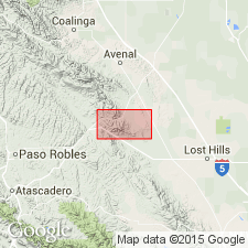
Type locality: section through Johnson Peak, Three Peaks anticline, Tent Hills quadrangle, Kern Co., southern CA. Crops out mainly east and northwest of Orchard Peak and in Three Peaks anticline.
Source: US geologic names lexicon (USGS Bull. 1200, p. 1931-1932).
- Usage in publication:
-
- Johnson Peak Formation
- Modifications:
-
- Overview
- AAPG geologic province:
-
- San Joaquin basin
Summary:
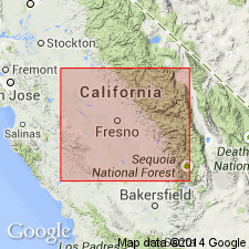
zzzzzArea of report is Avenal Ridge-Reef Ridge area of southern Diablo Range, 200 miles southeast of San Francisco, in Fresno and Kings Counties, west-central California. Eight stratigraphic units ranging from Early to Late Cretaceous are recognized in area, in descending [ascending?] order: Badger Shale, Risco Formation, Johnson Peak Formation, Catskin Formation (new), Lovel Shale (new), Redman [Red Man] Sandstone, Willow Spring Mudstone (new), and Moreno Formation. All rocks are marine of shallow neritic to bathyl depths and consist of thick sequences of mudstone, shale, thin- to thick-bedded concretionary sandstones and conglomerates. Unconformities exist between [Red Man] (Campanian) and Willow Spring (Maastrichtian); [Red Man] and Lovel (Santonian); and Lovel and Catskin (Cenomanian to Coniacian).
Source: US geologic names lexicon (USGS Bull. 1350, p. 130, 443, 832); supplemental information from GNU records (USGS DDS-6; Menlo GNULEX).
For more information, please contact Nancy Stamm, Geologic Names Committee Secretary.
Asterisk (*) indicates published by U.S. Geological Survey authors.
"No current usage" (†) implies that a name has been abandoned or has fallen into disuse. Former usage and, if known, replacement name given in parentheses ( ).
Slash (/) indicates name conflicts with nomenclatural guidelines (CSN, 1933; ACSN, 1961, 1970; NACSN, 1983, 2005, 2021). May be explained within brackets ([ ]).