

- Usage in publication:
-
- Jetmore chalk member*
- Modifications:
-
- Named
- Dominant lithology:
-
- Chalk
- Shale
- Limestone
- AAPG geologic province:
-
- Central Kansas uplift
Summary:
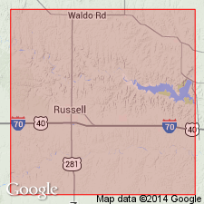
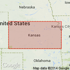
Named as one of four members of Greenhorn limestone in Russell Co, KS, Central Kansas uplift, for exposures south and east of Jetmore, along south side of Buckner Creek, Hodgeman Co, KS in Anadarko basin. Good exposures in secs 17 and 20, T13S, R14W. Composed of alternating thin beds of chalk and chalky shale that occupy the interval from 20-40 ft below top of Greenhorn. Uppermost bed--"INOCERAMUS limestone" or "shell bed" of oil geologists--is a hard, light-buff-gray, thin-bedded to massive, very fossiliferous (INOCERAMUS, BACULITES), fine-grained, chalky limestone about a ft thick. Below its upper bed, Jetmore is an alternating series of chalk and chalky shale. The layers of chalk decrease downward in thickness from 6 in to 1 in; the marl beds decrease in thickness from about 2 ft to 2 in. Overlies unnamed member and underlies upper [unnamed] member, both of Greenhorn. Columnar section. Cross section. Stratigraphic chart. Age is Late Cretaceous.
Source: GNU records (USGS DDS-6; Denver GNULEX).
- Usage in publication:
-
- Jetmore chalk member*
- Modifications:
-
- Contact revised
- AAPG geologic province:
-
- Central Kansas uplift
- Anadarko basin
Summary:
Upper and lower contacts of Jetmore chalk member of Greenhorn limestone revised in report area, Ellis Co, KS, Central Kansas uplift. Greenhorn now divided into (ascending): Lincoln limestone member, Hartland shale member (new, this report; previously unnamed), Jetmore chalk member (contacts revised, this report), and Pfeifer shale member (new, this report; previously unnamed). Nearly 150 mi southwest of Ellis Co where the Greenhorn is exposed along the Arkansas valley in Kearny and Hamilton Cos, Anadarko basin, the four divisions of Greenhorn can be recognized, but upper two are less easily distinguishable. There the entire formation has a thickness of 130 ft; the upper 74 ft is made up of beds corresponding to Pfeifer shale and Jetmore chalk members--these beds are here named Bridge Creek limestone member of Greenhorn. Bridge Creek overlies Hartland shale member in this area. Is of Late Cretaceous age. Stratigraphic chart.
Source: GNU records (USGS DDS-6; Denver GNULEX).
- Usage in publication:
-
- Jetmore Chalk Member*
- Modifications:
-
- Age modified
- Biostratigraphic dating
- AAPG geologic province:
-
- Salina basin
- Central Kansas uplift
- Anadarko basin
Summary:
Is member of Greenhorn Limestone; Lincoln, Mitchell, Republic, and Washington Cos, KS, Salina basin; Russell Co, KS, Central Kansas uplift; and Hodgeman Co, KS, Anadarko basin. Age is refined to early Turonian (Late Cretaceous) on basis of ammonites. WATINOCERAS HATTINI n. sp. identified from numerous localities including USGS Mesozoic localities D1835, D11643, D10400. Fauna places unit in upper zone of tripartite ammonite zonation of the early Turonian. W. HATTINI n. sp. also noted to occur in Cone Member of Marias River Shale in northwestern Montana.
Source: GNU records (USGS DDS-6; Denver GNULEX).
For more information, please contact Nancy Stamm, Geologic Names Committee Secretary.
Asterisk (*) indicates published by U.S. Geological Survey authors.
"No current usage" (†) implies that a name has been abandoned or has fallen into disuse. Former usage and, if known, replacement name given in parentheses ( ).
Slash (/) indicates name conflicts with nomenclatural guidelines (CSN, 1933; ACSN, 1961, 1970; NACSN, 1983, 2005, 2021). May be explained within brackets ([ ]).