

- Usage in publication:
-
- Jericho Run Member*
- Modifications:
-
- Named
- Dominant lithology:
-
- Mudstone
- Conglomerate
- Chert
- Sandstone
- AAPG geologic province:
-
- Atlantic Coast basin
Summary:
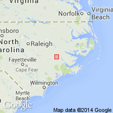
Jericho Run Member, named in Graingers area, Lenoir Co., NC, assigned to base of Beaufort Formation. Described as black to gray siliceous mudstone with basal conglomerate and chert and sandstone layers. Friable to extremely hard; silicified microfossils poorly preserved. Member ranges from 0.9 to 2.7 m. Disconformably overlies Peedee Formation. Age is early Paleocene (Danian).
Source: GNU records (USGS DDS-6; Reston GNULEX).
- Usage in publication:
-
- Jericho Run Member
- Modifications:
-
- Overview
- AAPG geologic province:
-
- Atlantic Coast basin
Summary:
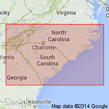
In the Albemarle embayment of NC, the Beaufort Formation consists of two members: the lower Jericho Run and the Moseley Creek Member, formally named in this report. These two members are recognized in outliers in the upper part of the middle Coastal Plain and are separated from the main body of the Paleocene strata that occurs in the subsurface in the outer part of the Coastal Plain. The Jericho Run is siliceous indurated claystone and shale up to about 8.5 m in thickness. The member is correlated downdip in the outer Coastal Plain to a 40- to 60-m-thick lower Paleocene sequence. Unit has been assigned to planktonic foraminiferal zones P1 and P2 (Danian). The new Moseley Creek Member has been assigned to zone P4 (Thanetian).
Source: GNU records (USGS DDS-6; Reston GNULEX).
For more information, please contact Nancy Stamm, Geologic Names Committee Secretary.
Asterisk (*) indicates published by U.S. Geological Survey authors.
"No current usage" (†) implies that a name has been abandoned or has fallen into disuse. Former usage and, if known, replacement name given in parentheses ( ).
Slash (/) indicates name conflicts with nomenclatural guidelines (CSN, 1933; ACSN, 1961, 1970; NACSN, 1983, 2005, 2021). May be explained within brackets ([ ]).