The National Geologic Map Database is migrating to a new infrastructure. We apologize for any service disruptions during this process.
|
|---|


- Usage in publication:
-
- Jens formation
- Modifications:
-
- Named
- Dominant lithology:
-
- Siltstone
- Mudstone
- Shale
- Sandstone
- AAPG geologic province:
-
- Montana folded belt
Summary:
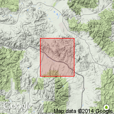
Named as a formation of "upper Colorado group" for village of Jens, Powell Co, MT, Montana folded belt province. Type section measured in NW1/4 sec 21 and NE1/4 sec 20, T10N, R11W. Composed of dark gray shale, siltstone, siliceous mudstone, and minor fine-grained calcareous sandstone. Increased thickness from 1,000 ft east of Gough Creek to 1,510 ft at Hoover Creek due to addition of a volcanic-rich sedimentary siltstone in middle part. Overlies Coberly formation (new), lower formation of "upper Colorado group" and underlies Carter Creek formation (new), upper formation of "upper Colorado group." Probably is lateral equivalent of Ferdig shale member of Marias River shale. Of Cretaceous age.
Source: GNU records (USGS DDS-6; Denver GNULEX).
- Usage in publication:
-
- Jens Formation*
- Modifications:
-
- Age modified
- Overview
- AAPG geologic province:
-
- Montana folded belt
Summary:
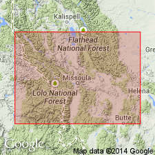
Occurs in area of Drummond, Granite Co, MT and Anaconda, Deer Lodge Co, MT, south of Lewis and Clark line (a west- and northwest-trending fault zone in west-central MT), Montana folded belt province. Consists of thick sequence of shale, sandstone, tuff and porcellenite deposited under marine conditions. Age is middle Turonian to middle Coniacian (about 89.5-88 Ma). INOCERAMUS FRECHI collected from a shale near top of Jens indicates an early Coniacian age (A. E. Merewether, 1983, written commun.) and these beds directly underlie middle Coniacian sandstone of Carten Creek; overlies Coberly Formation which is middle Turonian age in upper part based on RHYNCHOSTREON SUBORBICULATUM (W. A. Cobban, 1977, written commun.). Correlates in part with Ferdig and Kevin Members of Marias River Shale in Wolf Creek area on north side of Lewis and Clark line in Lewis and Clark and Cascade Cos, MT.
Source: GNU records (USGS DDS-6; Denver GNULEX).
For more information, please contact Nancy Stamm, Geologic Names Committee Secretary.
Asterisk (*) indicates published by U.S. Geological Survey authors.
"No current usage" (†) implies that a name has been abandoned or has fallen into disuse. Former usage and, if known, replacement name given in parentheses ( ).
Slash (/) indicates name conflicts with nomenclatural guidelines (CSN, 1933; ACSN, 1961, 1970; NACSN, 1983, 2005, 2021). May be explained within brackets ([ ]).