The National Geologic Map Database is migrating to a new infrastructure. We apologize for any service disruptions during this process.
|
|---|


- Usage in publication:
-
- Jealousy formation*
- Modifications:
-
- Named
- Dominant lithology:
-
- Clay
- Conglomerate
- AAPG geologic province:
-
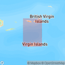
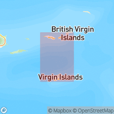
- Caribbean region
Summary:
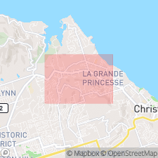
Probably named for Estate Jealousy [derivation not given]. Named for dark clays and associated conglomerates found in a test well; not known to crop out. Underlies Kingshill marl. Shown on map as a thin band of rock trending southwest to northeast, from Upper Loye to near Colquhoun in west-central St. Croix. Microfossils found in well cuttings indicate that upper part of formation is Oligocene.
Source: GNU records (USGS DDS-6; Reston GNULEX).
- Usage in publication:
-
- Jealousy formation*
- Modifications:
-
- Revised
- Age modified
- Biostratigraphic dating
- AAPG geologic province:
-
- Caribbean region
Summary:
Deeper well drilling revealed a thicker Tertiary section. A plain test hole near Bethlehem shows that Kingshill marl is underlain by a thicker Jealousy formation, which is a dark, clayey unit at least 1,398 ft thick; maximum thickness unknown. Section shows (ascending) 305 ft of dark clay with streaks of limestone, 5 ft of calcareous conglomerate, and 987 ft of greenish-gray clay. Near Jealousy Estate, formation is 368 ft thick; test drilling (well 39) shows 61 ft of hard calcareous conglomerate immediately above basement rocks (Mount Eagle volcanics). Calcareous conglomerate underlying Kingshill marl in stream beds near Jealousy is basal conglomerate of Jealousy formation. Foraminifera identified by T.W. Vaughan and F.G. Henbest indicate an Oligocene age. Cushman (1946) identified fossils in well cuttings of Jealousy and determined a late Oligocene age.
Source: GNU records (USGS DDS-6; Reston GNULEX).
- Usage in publication:
-
- Jealousy Formation
- Modifications:
-
- Age modified
- AAPG geologic province:
-
- Caribbean region
Summary:
Age of Jealousy Formation is late Oligocene, but may be older because bottom of formation has not been reached. Is shown on map as late Oligocene.
Source: GNU records (USGS DDS-6; Reston GNULEX).
- Usage in publication:
-
- Jealousy Formation
- Modifications:
-
- Age modified
- AAPG geologic province:
-
- Caribbean region
Summary:
Author questions much of Oligocene evidence in Caribbean. Age of Jealousy Formation is changed to late Oligocene and Miocene.
Source: GNU records (USGS DDS-6; Reston GNULEX).
- Usage in publication:
-
- Jealousy Formation
- Modifications:
-
- Age modified
- AAPG geologic province:
-
- Caribbean region
Summary:
Jealousy Formation shown as late Oligocene in age in generalized stratigraphic column.
Source: GNU records (USGS DDS-6; Reston GNULEX).

- Usage in publication:
-
- Jealousy Formation
- Modifications:
-
- Revised
- AAPG geologic province:
-
- Caribbean region
Summary:
Unit is entirely substrate. Conglomerates of detrital rocks cemented with carbonate mud are exposed along southern edge of Northside Range. They may be either Jealousy or Kingshill beach deposits. Highly weathered exposures show apparent conformity and gradational lithologies between the conglomerates and true Kingshill; therefore, exposed conglomerates are reassigned from Jealousy Formation to Kingshill Limestone.
Source: GNU records (USGS DDS-6; Reston GNULEX).
- Usage in publication:
-
- Jealousy Formation*
- Modifications:
-
- Age modified
- Biostratigraphic dating
Summary:
Discusses possibility that forams show age of Jealousy to range from Eocene to Miocene, based on examination of a fossil-rich mudball. The mudball may represent part of the Jealousy Formation thought by Cedarstrom (1941, 1950) and Whetten (1966) to be Oligocene, but whose age remains less certain to others (Van den Bold, 1970).
Source: GNU records (USGS DDS-6; Reston GNULEX).
- Usage in publication:
-
- Jealousy Formation
- Modifications:
-
- Age modified
- Biostratigraphic dating
- AAPG geologic province:
-
- Caribbean region
Summary:
Jealousy Formation is mainly bluish clay with abundant planktic forams. Is early-mid Miocene age but no doubt extends into Oligocene.
Source: GNU records (USGS DDS-6; Reston GNULEX).
- Usage in publication:
-
- Jealousy Formation*
- Modifications:
-
- Age modified
- Biostratigraphic dating
- AAPG geologic province:
-
- Caribbean region
Summary:
The Oligocene-Miocene boundary in borehole cuttings lies within Jealousy Formation based on assignment of Jealousy clays occurring immediately below Kingshill Limestone in boreholes M1 and M2 to the upper lower Miocene and mid-middle Miocene, respectively (Van den Bold, in Gill and Hubbard, 1986). Boundary position is also supported by assignment to the upper lower Miocene for a lens of green clay within Jealousy conglomerate from Northside Range; clay contained ostracodes that correlate with foraminiferal zones N7 or N8 (Van den Bold, 1970). Andreieff and others (1986) assign Jealousy conglomerate to same zones on basis of benthic and planktonic Foraminifera and the nannoflora. Latest deposition of Jealousy therefore occurred during late early Miocene and early middle Miocene and was contemporaneous with Kingshill deposition; the boundary between the two formations is time-transgressive, becoming younger to the north. The oldest fossils from Well 39 are late Oligocene, but base of formation must be much older based on unknown thickness of Jealousy Formation and Eocene through Miocene fossils in mudball described by Lidz (1984). According to Whetten (1966), there may be as much as 1.7 km (5,500 ft) of unexposed Tertiary sediment of unknown origin between Jealousy and underlying Judith Fancy Formations.
Source: GNU records (USGS DDS-6; Reston GNULEX).
- Usage in publication:
-
- Jealousy Formation*
- Modifications:
-
- Overview
- AAPG geologic province:
-
- Caribbean region
Summary:
Author follows usage of Whetten (1966) for the geologic units on St. Croix, VI. They include (ascending) the Late Cretaceous Mount Eagle Group, which consists of the Caledonia Formation, Allandale Formation, Cane Valley Formation (and its East End Member), and Judith Fancy Formation; Late Cretaceous Southgate Diorite and Fountain Gabbro intrusions; and Tertiary Jealousy Formation (early Eocene to middle Miocene) and Kingshill Marl (late Miocene, based on Gill, 1990).
Source: GNU records (USGS DDS-6; Reston GNULEX).
For more information, please contact Nancy Stamm, Geologic Names Committee Secretary.
Asterisk (*) indicates published by U.S. Geological Survey authors.
"No current usage" (†) implies that a name has been abandoned or has fallen into disuse. Former usage and, if known, replacement name given in parentheses ( ).
Slash (/) indicates name conflicts with nomenclatural guidelines (CSN, 1933; ACSN, 1961, 1970; NACSN, 1983, 2005, 2021). May be explained within brackets ([ ]).