

- Usage in publication:
-
- Jackson group
- Modifications:
-
- Original reference
- Dominant lithology:
-
- Marl
- Limestone
- AAPG geologic province:
-
- Mid-Gulf Coast basin
Summary:
Pg. 257-258. Jackson group. [This report lists "groups of characteristic fossils" from "Newer Eocene" and "Older Eocene" of Mississippi. The "Older Eocene" is divided into (descending) Jackson and Claiborne groups. The Jackson (fossil group No. 4) includes no Vicksburg species, and 5 only of Claiborne species. Author believes the group to be newer than Claiborne deposit and certainly older than that at Vicksburg; see also entry under Vicksburg.]
Source: US geologic names lexicon (USGS Bull. 896, St. Stephens entry p. 1886, Vicksburg entry p. 2246).
- Usage in publication:
-
- Jackson group
- Modifications:
-
- Original reference
- Dominant lithology:
-
- Marl
- Limestone
- AAPG geologic province:
-
- Mid-Gulf Coast basin
Summary:
Pg. 257-258. Jackson group. Marls and soft limestones, the marls white and blue, and often indurate. [Fossils listed.] ZEUGLODON common. Thickness 80 feet. Underlies Red Bluff group, which seems to be intermediate, in position and fossils, between Vicksburg group above and Jackson group below. [Age is late Eocene.]
Source: US geologic names lexicon (USGS Bull. 896, p. 1035).

- Usage in publication:
-
- Jackson group
- Modifications:
-
- Areal extent
- AAPG geologic province:
-
- Mid-Gulf Coast basin
Summary:
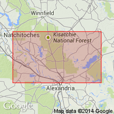
Pg. 29-41. Jackson group is present at Red Bluff, where it underlies Red Bluff group. [Age is late Eocene.]
Source: US geologic names lexicon (USGS Bull. 896, p. 1035).
- Usage in publication:
-
- Jackson formation*
- Modifications:
-
- Revised
- AAPG geologic province:
-
- Mid-Gulf Coast basin
Summary:
Pg. 187-190. Typical Jackson formation of Mississippi is composed chiefly of more or less calcitic clay and less prominent sand and marl beds, divided into Yazoo clay member above [70 to 600 feet thick] and Moodys calcitic marl member below [35 to 90 feet thick]. It underlies Vicksburg group (Oligocene), the basal formation of which is Red Bluff clay (marine) and the contemporaneous Forest Hill sand (shallow water). Overlies Claiborne group (middle Eocene). Contains a large marine fauna. [Cooke also stated (Alabama Geol. Survey Spec. Rpt., no. 14, p. 274, 1926) that at its type locality (Jackson, Mississippi) the formation consists chiefly of massive, plastic, gray clay with a sandy shell bed at base.]
[GNC remark (ca. 1936, US geologic names lexicon, USGS Bull. 896, p. 1035): Most early reports excluded the Red Bluff clay ("group") from the Jackson, and either treated it as distinct from the Vicksburg or included it in the Vicksburg. The Forest Hill (†Madison) sand has also been both included in and excluded from the Jackson, but it is now generally agreed that it is probably approximately contemporaneous with Red Bluff clay and more properly belongs in Vicksburg group. (See under Red Bluff clay.)]
Source: US geologic names lexicon (USGS Bull. 896, p. 1035).

- Usage in publication:
-
- Jackson formation*
- Modifications:
-
- Overview
- AAPG geologic province:
-
- Arkla basin
- Desha basin
- Gulf Coast basin
- Mid-Gulf Coast basin
- Upper Mississippi embayment
Summary:
The Jackson formation is now recognized by the USGS from southern Texas to Tombigbee River in southwestern Alabama. East of Tombigbee River in Alabama and in western Georgia the deposits of Jackson age are represented by Ocala limestone; farther east in Georgia and in western South Carolina they are represented by Barnwell formation; in eastern South Carolina they are represented by Cooper marl (above) and Santee limestone (below). The Fayette sandstone of eastern Texas is also of Jackson age.
Named from exposures at Jackson, MS, along Pearl River and Moodys Branch.
See also Fayette sandstone.
Source: US geologic names lexicon (USGS Bull. 896, p. 1035).
- Usage in publication:
-
- Jackson group
- Modifications:
-
- Revised
- AAPG geologic province:
-
- Mid-Gulf Coast basin
Hanna, M.A., and Gravell, Donald, 1934, [Chart and discussoin] IN McGuirt, James, Bryozoa of the upper and lower Chickasawhay members of the Catahoula formation of Wayne County, Mississippi: Shreveport Geological Society Guidebook, Annual Field Trip, no. 11, p. 28+.
Summary:
Chart facing p. 30. Jackson group. Correlation chart shows Jackson comprises (ascending) Moodys Branch, Yazoo, and Danville Landing (new) groups. Danville Landing group contains Danville Landing beds. [Use of term group not explained.]
Source: US geologic names lexicon (USGS Bull. 1200, p. 1900-1901).
- Usage in publication:
-
- Jackson group
- Modifications:
-
- Revised
- AAPG geologic province:
-
- Gulf Coast basin
Summary:
Pg. 13-55. Jackson group comprises (ascending) Caddell (Moodys marl), Wellborn (with Bedias and Carlos sandstones), Manning (with Dilworth and Yuma sandstones), and Whitsett formations. Overlies Yegua formation of Claiborne group; underlies Catahoula formation. [Age is late Eocene.]
Source: US geologic names lexicon (USGS Bull. 1200, p. 1900-1901).
- Usage in publication:
-
- Jackson group
- Modifications:
-
- Areal extent
- AAPG geologic province:
-
- Arkla basin
Summary:
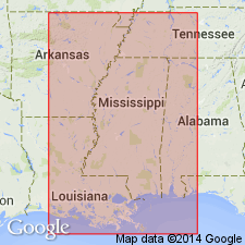
Pg. 89-111. In central Louisiana, outcrop of Jackson group extends southwestward in narrow belt from Ouachita River in southern Caldwell Parish to Red River south of Montgomery. Covers most of northwestern La Salle Parrish and northern third of Grant Parish. Includes (ascending) Moodys Branch marl, Yazoo clay, and Danville Landing beds. Underlies Vicksburg group; overlies Cockfield formation of Claiborne group, transition zone. Age is late Eocene.
Source: US geologic names lexicon (USGS Bull. 1200, p. 1900-1901).
- Usage in publication:
-
- Jackson group*
- Modifications:
-
- Revised
- AAPG geologic province:
-
- Mid-Gulf Coast basin
Summary:
Pg. 337-340. Jackson raised to group rank in Mississippi where Moodys marl is basal formation. Name Moodys replaces name Gosport. Hence, Claiborne group restricted to formations heretofore classified as lower Claiborne.
Source: US geologic names lexicon (USGS Bull. 1200, p. 1900-1901).
- Usage in publication:
-
- Jackson group
- Modifications:
-
- Revised
- AAPG geologic province:
-
- Mid-Gulf Coast basin
Summary:
Pg. 40-46. Gosport sand has been transferred from Claiborne group to Jackson group (Cooke, 1939). Cooke (1939) and Gardner (USGS Prof. Paper 189-F, 1939) advocate dropping name Gosport and applying name Moodys marl to deposits in Alabama heretofore known as Gosport. In present report, name Gosport sand is retained for those beds in Alabama traditionally known by that name. Formations of Jackson group west of Tombigbee River are Moodys marl and Yazoo clay. Ocala limestone in eastern Alabama, southwestern Georgia, and Florida is probably equivalent to Moodys marl and Yazoo clay. Disconformably overlies Claiborne formation; conformably underlies Red Bluff clay of Vicksburg group. [Age is late Eocene.]
Source: US geologic names lexicon (USGS Bull. 1200, p. 1900-1901).
- Usage in publication:
-
- Jackson [group]
- Modifications:
-
- Areal extent
- AAPG geologic province:
-
- Arkla basin
- Mid-Gulf Coast basin
Summary:
Pg. 1837-1839. In central Gulf Coastal Plain, sediments of Jackson age crop out in northwest-southeast-trending belt across central Mississippi and southern Alabama and in southwest-trending belt across central Louisiana. Isolated outcrops exposed in Embayment areas as far north as Kentucky. In type area, Jackson [group] consists of thin basal transgressive beach sand (Moodys formation) and an upper blue-gray fossiliferous clay (Yazoo). Yazoo is increasingly calcareous eastward and, in eastern Mississippi and western Alabama, is divisible into four members (ascending): North Creek clay (new), Cocoa sand, Pachuta marl (new), and Shubuta clay (new). In central Louisiana, Danville Landing formation is present above Yazoo clay. Farther east in Alabama entire Jackson changes to lime facies (Ocala limestone). Above Claiborne group; below Vicksburg group. [Age is late Eocene.]
Source: US geologic names lexicon (USGS Bull. 1200, p. 1900-1901).
- Usage in publication:
-
- Jackson group
- Modifications:
-
- Areal extent
- AAPG geologic province:
-
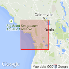
- Florida platform
Summary:
Pg. 11-172. Applin and Applin (1944) recognized in Jackson group and in Ocala limestone an upper and lower member and separated from base of Ocala limestone by about 80 feet of section that is composed of two lithologically and faunally distinct beds, about 30 and 50 feet thick. This interval is correlated with Moodys Branch formation, and names Williston and Inglis are here proposed for the two members. As used in this report [Citrus and Levy Counties], the upper Eocene, Jackson group of peninsular Florida, is composed of two formations, Ocala limestone (restricted) and Moodys Branch formation, Jackson-Claiborne contact is placed at top Avon Park limestone. Jackson group separated from older beds by disconformity.
Source: US geologic names lexicon (USGS Bull. 1200, p. 1900-1901).
- Usage in publication:
-
- Jackson group
- Modifications:
-
- Areal extent
- AAPG geologic province:
-
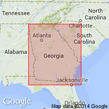
- South Georgia sedimentary province
Summary:
Pg. 321-347. Discussion of Jackson group in Georgia. Outcrop area extends along inner edge of coastal plain from Seminole County to Savannah River. Includes Ocala limestone and Barnwell formation. Cooper marl not believed to be present in Georgia. [Age is late Eocene.]
Source: US geologic names lexicon (USGS Bull. 1200, p. 1900-1901).
- Usage in publication:
-
- Jackson group
- Modifications:
-
- Areal extent
- AAPG geologic province:
-
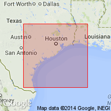
- East Texas basin
- Gulf Coast basin
Summary:
Pg. 2623-2635. Jackson group in south-central Texas consists of (ascending) Caddell, Wellborn, McElroy, and Whitsett formations. Group is used in this report only a rock unit term.
Source: US geologic names lexicon (USGS Bull. 1200, p. 1900-1901).
- Usage in publication:
-
- Jackson group
- Modifications:
-
- Areal extent
- Age modified
- AAPG geologic province:
-
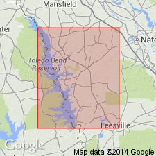
- Arkla basin
Summary:
Pg. 94-102, maps. Jackson group. In Sabine Parish, group comprises (ascending) Moodys Branch formation, Yazoo formation, Danville Landing beds, and Mosley Hill formation (redefined). Overlies Cockfield formation of Claiborne group; underlies Sandel formation (new). Age is Oligocene.
Source: US geologic names lexicon (USGS Bull. 1200, p. 1901).
- Usage in publication:
-
- Jackson Formation*
- Modifications:
-
- Areal extent
- AAPG geologic province:
-
- Upper Mississippi embayment
Summary:
Jackson Formation extended to TN and western KY.
Source: GNU records (USGS DDS-6; Reston GNULEX).

- Usage in publication:
-
- Jackson Group
- Modifications:
-
- Mapped 1:250k
- AAPG geologic province:
-
- Gulf Coast basin
Summary:
Jackson Group. Includes (ascending) Caddell Formation, Wellborn Sandstone, Manning Formation, and Whitsett Formation. [Composite thickness up to 875 feet.] Overlies Yegua Formation. Underlies Frio Formation (Oligocene); [where Frio is absent, underlies Catahoula Formation (Miocene)]. Age is Eocene.
[Mapped in Webb, Duval, La Salle, McMullen, Atascosa, Live Oak, Karnes, and Wilson Cos., southern TX.]
Source: Publication.

- Usage in publication:
-
- Jackson Group
- Modifications:
-
- Overview
- Dominant lithology:
-
- Clay
- Sand
- Marl
- AAPG geologic province:
-
- Mid-Gulf Coast basin
Summary:
Upper Eocene (Bartonian-Priabonian) Jackson Group includes the Moodys Branch Formation, the Yazoo Clay, and the Crystal River Formation in the study area. Yazoo Clay is further subdivided into the North Twistwood Creek Clay, the Cocoa Sand, the Pachuta Marl, and the Shubuta Members. Jackson disconformably overlies middle Eocene Claiborne Group.
Source: GNU records (USGS DDS-6; Reston GNULEX).
For more information, please contact Nancy Stamm, Geologic Names Committee Secretary.
Asterisk (*) indicates published by U.S. Geological Survey authors.
"No current usage" (†) implies that a name has been abandoned or has fallen into disuse. Former usage and, if known, replacement name given in parentheses ( ).
Slash (/) indicates name conflicts with nomenclatural guidelines (CSN, 1933; ACSN, 1961, 1970; NACSN, 1983, 2005, 2021). May be explained within brackets ([ ]).