

- Usage in publication:
-
- Ingleside formation
- Modifications:
-
- Original reference
- Dominant lithology:
-
- Sandstone
- Limestone
- AAPG geologic province:
-
- Denver basin
Summary:
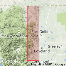
Pg. 68, 75, etc. Ingleside formation. Alternating limestones and hard fine-grained sandstones, gray to almost white, through pink to almost red; basal Ingleside is a light-colored sandstone somewhat harder than the rest. Name is considered necessary to avoid confusion by use of Lyons in too broad a sense. Is quite different from the Lyons as described by Fenneman, especially in fact it contains the limestone bands, some of them very pure. Is also in a different and lower horizon than the Lyons. It lies conformably on Fountain formation. Possibly it should be regarded as merely a lithological unit in the Fountain, showing a change in conditions of sedimentation transitional to Lykins conditions. Contact with Fountain is hard to place, but appears to be at top of last prominent band of arkose conglomerate, though there are bands of sandstone in the Fountain similar to those in the Ingleside. It extends geographically from beyond State line to the north to a point a little north of Lyons [Boulder County, central northern Colorado]. Typically developed at Ingleside quarries and at Owl Canyon, [3 mi north of Ingleside], Larimer County, central northern Colorado. Thickness 100 to 125 feet. Underlies Lyons sandstone. [Age is Pennsylvanian.]
Source: US geologic names lexicon (USGS Bull. 896, p. 1013).
- Usage in publication:
-
- Ingleside formation*
- Modifications:
-
- Revised
- AAPG geologic province:
-
- Denver basin
Summary:
Ingleside formation. Published the following as his interpretation of the section at Ingleside, Colorado:
-----------------------------------------
Lykins formation (basal part):
(1) "Crinkled sandstone," brecciated limestone gypsum, and red shale, 75+/- feet.
(2) shale, red, soft, 175 feet.
-----------------------------------------
Lyons sandstone, 25 feet (sandstone, yellowish pink, cross-bedded, ridge making).
-----------------------------------------
Satanka(?) shale, 375 feet (red shale, poorly exposed, with thin layers of ridge-making sandstone). "Possibly belongs with underlying formation."
-----------------------------------------
Ingleside formation:
(1) sandstone, ledge making, red to yellowish pink (Tensleep sandstone of Darton), 65 feet.
(2) limestone, pink to gray, with many solution cavities and masses of calcite, 25 feet.
(3) sandstone, red, intensely cross-bedded, 25 feet.
(4) limestone, gray, brittle, impure, in places variable, 22 feet.
(5) sandstone, red, massive, cross-bedded, 40 feet.
(6) sandstone, limy, gray, quartzose, 6 feet.
(7) shale, soft, red.
(8) sandstone, red, ledge-making, 100+/- feet.
-----------------------------------------
Fountain formation
-----------------------------------------
Pl. 1 showed Satanka(?) shale as thinning out before reaching Spring Canyon, Larimer County, where the Ingleside was shown as overlain unconformably by Lyons sandstone as restricted by Lee. [Age is Pennsylvanian.]
Source: US geologic names lexicon (USGS Bull. 896, p. 1013).
- Usage in publication:
-
- Ingleside formation
- Modifications:
-
- Areal extent
- AAPG geologic province:
-
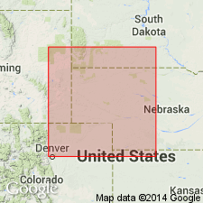
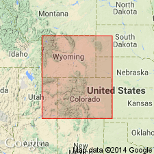
- Denver basin
- Powder River basin
Summary:
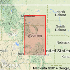
Recognized in sections from Owl Canyon, Larimer County, Colorado, north to La Bonte Post Office [sec. 5, T. 29 N., R. 72 W.] Converse County, Wyoming (Powder River basin). Underlies Owl Canyon Formation (new) at most localities. Age is Pennsylvanian. Report includes measured sections.
Source: Modified from GNU records (USGS DDS-6; Denver GNULEX).
- Usage in publication:
-
- Ingleside formation*
- Modifications:
-
- Age modified
- AAPG geologic province:
-
- Denver basin
Summary:
Ingleside formation. Ranges from 0 to 260 feet thick. "Type section," attributed to Butters (1913) [see entry under Butters; GNU records (USGS DDS-6; Denver GNULEX) state type locality not designated], described at Ingleside, in S/2 sec. 25, T. 9 N., R. 70 W., Larimer Co., Colorado. Sandstone is mostly fine- to very fine-grained, subangular to round quartz. Stratification consists of horizontal laminae and thin beds, wedge-shaped planar sets. Limestone and dolomite are widespread [northward] to proximity of Hook and Moore Glade, in secs. 1 and 12, T. 8 N., R. 70 W., Larimer Co., Colorado. Correlates with upper part of Casper formation of southern Laramie Range, with all of Casper in Laramie basin, and with upper part of Fountain formation in central Front Range. Overlies part of Fountain formation; underlies Satanka shale. Fusulinids collected from Ingleside near Boxelder Creek and from basal strata of Ingleside at Owl Canyon, Larimer County, Colorado, indicate an Early Permian age. Was previously considered to be Pennsylvanian age.
See also Field trip B-2, Geology of the northern Front Range-Laramie Range, Colorado and Wyoming; two-day field trip -Cheyenne and Laramie, Wyoming, and Fort Collins, Colorado, via U.S. Highways 87, 85, 30, and 287 and local roads, p. 212-217, same volume.
Source: Modified from GNU records (USGS DDS-6; Denver GNULEX).
- Usage in publication:
-
- Ingleside Formation*
- Modifications:
-
- Age modified
- AAPG geologic province:
-
- Denver basin
Summary:
Described from near Bellevue, in Larimer County, Colorado, and Lyons, in Boulder County, Colorado, as a fine- to medium-grained arkose and subarkosic sandstone; [includes] some coarse-grained arkose. Carbonate rock more prominent [north of] Owl Canyon. Evaporite occurs in subsurface. Is equivalent to Chase Group of subsurface. Underlies the Owl Canyon Formation (adopted by the USGS). Age refined from Early Permian --to-- late Wolfcampian, early Early Permian.
Source: Modified from GNU records (USGS DDS-6; Denver GNULEX).
For more information, please contact Nancy Stamm, Geologic Names Committee Secretary.
Asterisk (*) indicates published by U.S. Geological Survey authors.
"No current usage" (†) implies that a name has been abandoned or has fallen into disuse. Former usage and, if known, replacement name given in parentheses ( ).
Slash (/) indicates name conflicts with nomenclatural guidelines (CSN, 1933; ACSN, 1961, 1970; NACSN, 1983, 2005, 2021). May be explained within brackets ([ ]).