The National Geologic Map Database is migrating to a new infrastructure. We apologize for any service disruptions during this process.
|
|---|


- Usage in publication:
-
- Indian Spring sandstone, red beds
- Modifications:
-
- Named
- Dominant lithology:
-
- Sandstone
- Redbeds
- AAPG geologic province:
-
- Appalachian basin
Summary:
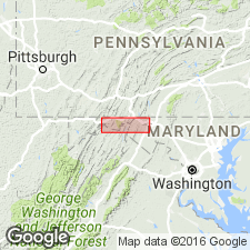
Indian Spring sandstone lies about 120 ft above the base of Tonoloway formation. Unit is thin and inconspicuous at Pinto, but increases in thickness eastward. In vicinity of Hancock it is argillaceous and about 5 ft thick. East of Hancock it becomes very hard and dense and breaks into irregular fragments. Seems to occupy stratigraphic position of Bloomfield sandstone of Claypole. The red beds here called Indian Spring red beds are associated with it in North Mountain, becoming conspicuous in easternmost exposures. Named here for occurrence at Indian Spring, Washington Co. [In tables the Indian Spring redbeds are placed beneath Indian Spring sandstone. Age is Silurian.
Source: GNU records (USGS DDS-6; Reston GNULEX).
- Usage in publication:
-
- Indian Spring sandstone, red beds
- Modifications:
-
- Overview
- AAPG geologic province:
-
- Appalachian basin
Summary:
Indian Spring sandstone and associated Indian Spring red beds apparently represent extensions of the red Bloomsburg facies into the Tonoloway. Age is Late Silurian.
Source: GNU records (USGS DDS-6; Reston GNULEX).
- Usage in publication:
-
- Indian Spring Sandstone Member
- Modifications:
-
- Revised
- AAPG geologic province:
-
- Appalachian basin
Summary:
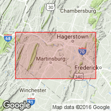
Referred to as Sandstone Member of Tonoloway Limestone. Described as gray, fine to medium-grained sandstone with tan, brown, and red shale and siltstone. 20 ft thick in east; thins to 5 ft in west. Overlies and underlies unnamed members of Tonoloway in north-central MD. Age is Silurian.
Source: GNU records (USGS DDS-6; Reston GNULEX).
For more information, please contact Nancy Stamm, Geologic Names Committee Secretary.
Asterisk (*) indicates published by U.S. Geological Survey authors.
"No current usage" (†) implies that a name has been abandoned or has fallen into disuse. Former usage and, if known, replacement name given in parentheses ( ).
Slash (/) indicates name conflicts with nomenclatural guidelines (CSN, 1933; ACSN, 1961, 1970; NACSN, 1983, 2005, 2021). May be explained within brackets ([ ]).