

- Usage in publication:
-
- Indian Hills volcanics*
- Modifications:
-
- Named
- Dominant lithology:
-
- Volcanics
- AAPG geologic province:
-
- Southwestern Basin-and-Range region
Summary:
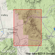
Is named from Indian Hills along the western front of the Black Hills, Yavapai Co, AZ, Southwestern Basin-and-Range region as lower formation of Alder group of Yavapai series. No type locality designated. Exposed in Indian Hills along west front of Black Hills and in low hills west of Coyote Spring ranch. Base not exposed. Stratigraphic relationships uncertain. Thickness uncertain. May be 6,500 ft thick. Appear to be conformably overlain by Spud Mountain volcanics (new) of Alder group. Made up of greenish-black andesitic and basaltic flows, and orange or green-gray rhyolitic flows. The andesite and basalt are blocky, porphyritic with a holocrystalline groundmass. Phenocrysts as much as three quarters of an in long are altered plagioclase and subordinate hornblende. The rhyolite flows are massive, flow banded, locally foliated. Are older Precambrian. Geologic map.
Source: GNU records (USGS DDS-6; Denver GNULEX).
- Usage in publication:
-
- Indian Hills Volcanics*†
- Modifications:
-
- Abandoned
Summary:
The lithologic similarity of Green Gulch Volcanics and Indian Hills Volcanics --both consist of basaltic and rhyolitic rocks --and both underlie Spud Mountain Breccia lead to the conclusion that two names have been applied to one stratigraphic unit. The name Green Gulch Volcanics is retained. The name Indian Hills Volcanics is abandoned. Revision of Precambrian Stratigraphy in the Prescott-Jerome Area, Yavapai County, Arizona: U.S. Geological Survey Bulletin 1324-C.
Source: GNU records (USGS DDS-6; Denver GNULEX).
For more information, please contact Nancy Stamm, Geologic Names Committee Secretary.
Asterisk (*) indicates published by U.S. Geological Survey authors.
"No current usage" (†) implies that a name has been abandoned or has fallen into disuse. Former usage and, if known, replacement name given in parentheses ( ).
Slash (/) indicates name conflicts with nomenclatural guidelines (CSN, 1933; ACSN, 1961, 1970; NACSN, 1983, 2005, 2021). May be explained within brackets ([ ]).