

- Usage in publication:
-
- Hye granite
- Modifications:
-
- Original reference
- Dominant lithology:
-
- [Granite]
- AAPG geologic province:
-
- Llano uplift
Summary:
Pg. 49, 50 (fig. 3). Mapped as Hye granite. Crops out as mass of weathered boulders and is part of old _monadnock of Precambrian peneplain which is surrounded by Cambrian sediments up to base of Wilberns formation. Age is Precambrian.
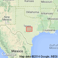
Type locality not stated. Derivation of name not stated. Outcrops in area along Pedernales River at Blanco-Gillespie Co. line, about 22 mi from Fredericksburg, central TX.
Source: US geologic names lexicon (USGS Bull. 1200, p. 1849-1850).
For more information, please contact Nancy Stamm, Geologic Names Committee Secretary.
Asterisk (*) indicates published by U.S. Geological Survey authors.
"No current usage" (†) implies that a name has been abandoned or has fallen into disuse. Former usage and, if known, replacement name given in parentheses ( ).
Slash (/) indicates name conflicts with nomenclatural guidelines (CSN, 1933; ACSN, 1961, 1970; NACSN, 1983, 2005, 2021). May be explained within brackets ([ ]).