The National Geologic Map Database is migrating to a new infrastructure. We apologize for any service disruptions during this process.
|
|---|


- Usage in publication:
-
- Hunton limestone*
- Modifications:
-
- Original reference
- Dominant lithology:
-
- Limestone
- Marl
- AAPG geologic province:
-
- Ouachita folded belt
- South Oklahoma folded belt
Summary:
Hunton Limestone. Nearly pure white limestone and limy marls. At base variable beds of white oolite, in parts of which coarse and fine spherical granules appear as if orginally sorted and stratified. Elsewhere spherules ranging in size from that of a small pea to fine grains appear to be intermingled; in places the oolite is silicified. Succeeding the oolite are bluish and cream-colored granular and fine-textured limestones and marly beds attaining thickness of 100+/- feet; many of these beds are crystalline and hard, while others are composed largely of comminuted shell fragments. Near top are marly beds which carry abundance of well-preserved fossils. Uppermost 50 feet of formation is for most part hard and thin-bedded. Many nodular cherty concretions and numerous fossils, some of which are beautifully silicified, occur in these beds. Overlies Sylvan shale and underlies Woodford chert. Age is Late Silurian, based on fossils.
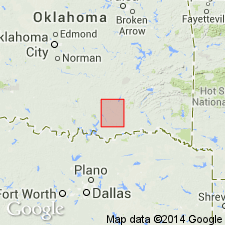
Named from exposures near former townsite of Hunton (T. 1 S., R. 8 E.), southwestern part of Coal Co., southeastern OK.
Source: US geologic names lexicons (USGS Bull. 896, p. 998-999, USGS Bull. 1200, p. 1843-1844).
- Usage in publication:
-
- Hunton group
- Modifications:
-
- Revised
- AAPG geologic province:
-
- Arkoma basin
- South Oklahoma folded belt
Summary:
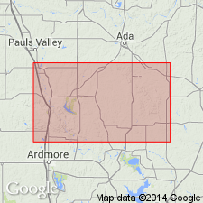
Hunton group. Hunton limestone of Taff is here [raised to group rank and] divided into 4 formations in the Arbuckle Mountains of south-central Oklahoma [in the Arkoma basin and in the S. Oklahoma folded belt province], in descending order: (1) Bois d'Arc limestone, 0 to 90 feet thick, of Becraft (Oriskany) age, according to C. Schuchert (1922) and E.O. Ulrich (1927); (2) Haragan shale, 0 to 166 feet thick, of New Scotland age; (3) Henryhouse shale, 0 to 223 feet thick, of Niagaran age; and (4) Chimneyhill limestone, 0 to 53 feet, of Alexandrian age. Underlain by Sylvan shale with unconformity. [Overlying unit not stated.] The Bois d'Arc limestone corresponds to upper Hunton of Taff; the Haragan and Henryhouse correspond to middle Hunton of Taff; and the Chimneyhill corresponds to lower Hunton of Taff. [Divisions are based on fossils and lithology, but primarily on fossil evidence. Measured as many as 35 sections, of which no two are alike; formation exposures and thicknesses vary. Report includes table of fossils found in each of the 4 formations, and in Hunton group; correlation table.]
Source: US geologic names lexicon (USGS Bull. 896, p. 999); supplemental information (in brackets) from GNU records (USGS DDS-6; Denver GNULEX).
- Usage in publication:
-
- Hunton Limestone Megagroup
- Modifications:
-
- Revised
Summary:
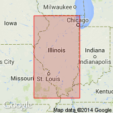
Pg. 471-483. Hunton Limestone Megagroup. Hunton Limestone or Hunton Group of Oklahoma (J.A. Taff, 1902, USGS Geol. Atlas U.S., Atoka folio, no. 79; T.W. Amsden, 1957, Oklahoma Geol. Survey Circ., no. 44) consists of Silurian and Devonian carbonates between Sylvan Shale (Cincinnatian) and shale or chert of Woodford Formation (Upper Devonian and Kinderhookian). Name Hunton Limestone Megagroup is herein applied to major body of Silurian and Devonian limestones and dolomites which, in central states, lies on clastic rocks ranging in age from Cincinnatian to early Niagaran and lies beneath clastic rocks ranging from late Middle Devonian to early Osagian. Panola Formation of central Kentucky is senior synonym of Hunton but is rejected because it has received little use, whereas Hunton is accepted for these rocks throughout Midcontinent region. The Hunton extends as useful megagroup into western part of Appalachian basin, then frays out into geosynclinal facies on east. It retains its usefulness in some parts of the Cordillera. Where top Hunton unit is younger than Camden, it is overlain in conformity or near conformity by only slightly younger clastics of Knobs Megagroup (new). Megagroup is about 1800 feet thick in southernmost Illinois and consists of an essentially uninterrupted sequence ranging in age from earliest Silurian to late Middle Devonian and early [Late] Devonian. In western Illinois thins to featheredges of early Alexandrian strata and of late Middle Devonian strata and is entirely lacking in small areas. In northern Illinois, consists of a few hundred feet of beds, largely Silurian. Term "megagroup" is proposed as formal designation for rock-stratigraphic unit larger than group. Although comparable in size with Series and Systems, megagroups are defined in terms of lithology and transect boundaries of units that are based on time of deposition.
Source: US geologic names lexicon (USGS Bull. 1350, p. 354-355).
For more information, please contact Nancy Stamm, Geologic Names Committee Secretary.
Asterisk (*) indicates published by U.S. Geological Survey authors.
"No current usage" (†) implies that a name has been abandoned or has fallen into disuse. Former usage and, if known, replacement name given in parentheses ( ).
Slash (/) indicates name conflicts with nomenclatural guidelines (CSN, 1933; ACSN, 1961, 1970; NACSN, 1983, 2005, 2021). May be explained within brackets ([ ]).