The National Geologic Map Database is migrating to a new infrastructure. We apologize for any service disruptions during this process.
|
|---|


- Usage in publication:
-
- Huntley Mountain Formation
- Modifications:
-
- Named
- Dominant lithology:
-
- Sandstone
- AAPG geologic province:
-
- Appalachian basin
Summary:
Huntley Mountain Formation. A nonmarine clastic succession; fining upward cycles in lower part. Consists mostly of sandstone, with minor siltstone, shale, and conglomerate; color is mostly greenish-gray to light-olive-gray. Is cross-bedded. Thickness 170 m at type section. Transitionally overlies Catskill Formation; transitionally underlies Burgoon Sandstone. Age is Late Devonian and Early Mississippian.
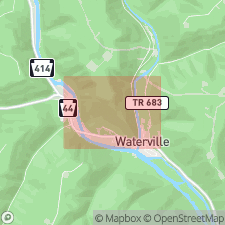
Type section: southeast slope of Huntley Mountain, northwest of village of Waterville, between Lat. 41 deg. 19 min. 09 sec. N., Long. 77 deg. 22 min. 20 sec. W. (top) and Lat. 41 deg. 18 min. 35 sec. N., Long. 77 deg. 21 min. 19 sec. W. (base), Waterville quadrangle, Lycoming Co., north-central PA.
Source: US geologic names lexicon (USGS Bull. 1564, p. 78-79).
For more information, please contact Nancy Stamm, Geologic Names Committee Secretary.
Asterisk (*) indicates published by U.S. Geological Survey authors.
"No current usage" (†) implies that a name has been abandoned or has fallen into disuse. Former usage and, if known, replacement name given in parentheses ( ).
Slash (/) indicates name conflicts with nomenclatural guidelines (CSN, 1933; ACSN, 1961, 1970; NACSN, 1983, 2005, 2021). May be explained within brackets ([ ]).