The National Geologic Map Database is migrating to a new infrastructure. We apologize for any service disruptions during this process.
|
|---|


- Usage in publication:
-
- Hunters Cove Formation
- Modifications:
-
- Named
- Biostratigraphic dating
- Dominant lithology:
-
- Sandstone
- AAPG geologic province:
-
- Oregon-Washington Coast Ranges province
Summary:
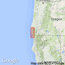
Named for exposures at Hunters cove near Cape Sebastian, Curry Co, OR. Type section measured at first headland north of cape (secs 25 and 36, T37S R15W), Gold Beach 15' quad, Curry Co. Type area is neck of cape from Black Rock to first headland north of cape. Crops out in Cape Sebastian area and south to near Houstenaden Creek; and at Edson Creek (Langlois quad), northeast of Blacklock Point (sec.19 T31S R15W Cape Blanco 15' quad), and near Mack Point (sec.5 T39S R14W, Cape Ferrelo 15' quad). Consists of alternating thin dark-gray to brown-weathering mudstone. Sandstone in beds 2-3 in. thick with abundant sedimentary structures, is poor in graded bedding. Mudstone in beds 10-12 in. thick with local light gray calcareous nodules. Includes local lenticular sandstone and conglomerate masses. Is 700-1000 ft thick in type area. Gradationally overlies Cape Sebastian sandstone (new) with of Hunters Cove placed at base of mudstone unit in 100 ft transition zone [Placement of boundary zone makes formation assignment difficult]; unconformably underlies Quaternary surficial deposits. Is Campanian and Maastrichtian (Late Cretaceous) based on INOCERAMUS and ammonoids in sandstone at Mack Point and Black Rock, and at Hunters Cove [age restricted MELAPLACENTECERA PACIFICUM is late Campanian; other fossils are Campanian and (or) Maastrichtian]. May correlate with Gualala Formation. (Point Arena, CA).
Source: GNU records (USGS DDS-6; Menlo GNULEX).
- Usage in publication:
-
- Hunters Cove Formation
- Modifications:
-
- Overview
- AAPG geologic province:
-
- Oregon-Washington Coast Ranges province
Summary:
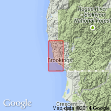
Distribution shown on detailed geologic maps of Cape Ferrelo, Gold Beach, Cape Blanco and Langlois 15' quads, Curry Co., OR. Is in fault contact with Otter Point Formation in Langlois and Cape Ferrelo 15' quads.
Source: GNU records (USGS DDS-6; Menlo GNULEX).
- Usage in publication:
-
- Hunters Cove Formation
- Modifications:
-
- Areal extent
- Overview
- AAPG geologic province:
-
- Oregon-Washington Coast Ranges province
Summary:
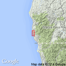
Geographically restricted from Houstenaden Creek and Mack Point areas; rocks in these areas reassigned to Houstenaden Creek Formation (new). Consists of: lower part of turbidites with interbedded faintly laminated and rippled siltstone and mudstone and local burrowed channeled sandstone and small-scale slumps present; most distinct rock is thick (1-14 m) fine-grained sandstone with many features and structures such as ripples and convolution. Represents deposition in deepening basin where turbidity currents dominated first followed by more pelagic conditions. Is in fault contact with Houstenaden Creek Formation and gradational contact with Cape Sebastian Sandstone. Age is late Campanian possibly to early Maastrichtian on basis of ammonites, dinoflagellates, and angiosperm pollen.
Source: GNU records (USGS DDS-6; Menlo GNULEX).
For more information, please contact Nancy Stamm, Geologic Names Committee Secretary.
Asterisk (*) indicates published by U.S. Geological Survey authors.
"No current usage" (†) implies that a name has been abandoned or has fallen into disuse. Former usage and, if known, replacement name given in parentheses ( ).
Slash (/) indicates name conflicts with nomenclatural guidelines (CSN, 1933; ACSN, 1961, 1970; NACSN, 1983, 2005, 2021). May be explained within brackets ([ ]).