The National Geologic Map Database is migrating to a new infrastructure. We apologize for any service disruptions during this process.
|
|---|


- Usage in publication:
-
- Hunsaker Creek Formation*
- Modifications:
-
- Named
- Reference
- Dominant lithology:
-
- Breccia
- Tuff
- Conglomerate
- Sandstone
- Siltstone
- AAPG geologic province:
-
- Snake River basin
Summary:
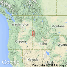
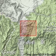
Name applied to one of four new formations assigned to Seven Devils Group (rank raised) exposed in Snake River Canyon for nearly 15 km north of Oxbow and in southeast part of Wallowa Mountains. Type section (785 m thick) is between 680 and 1,060 m, north side of Hunsaker Creek, OR, SW1/4 sec 5 and NE1/4 sec 6, T7S, R48E, Copperfield 15' quad, Baker Co, OR, Snake River basin. Reference section (676 m thick) is in W1/2 sec 11, T6S, R48E, Homestead 15' quad, Baker Co, OR. Extends into Adams Co, ID. Measured sections of type and reference. Top and base not exposed at either section. Total thickness unknown. Consists of pyroclastic breccia, agglomerate, tuff, epiclastic volcanic breccia, conglomerate, sandstone, siltstone, and minor limestone, quartz keratophyre and metamorphosed mafic rocks. Volcaniclastics are vertically graded. Spilite occurs as flows and irregular hypabyssal intrusions. Most specimens are porphyritic with phenocrysts of plagioclase and clinopyroxene. Chemical analyses. Fifty percent of formation is sandstone (a volcanic graywacke) and volcanic siltstone. Ten percent is conglomerate which grades from pebbly mudstone to conglomerate with cobble- to boulder-size clasts. Younger than Windy Ridge Formation (new) of Seven Devils; older than Wild Sheep Creek Formation (new) of Seven Devils. Early Permian age (Leonardian or early Guadalupian, Word, brachiopods). Geologic map. Stratigraphic column.
Source: GNU records (USGS DDS-6; Denver GNULEX).
- Usage in publication:
-
- Hunsaker Creek Formation*
- Modifications:
-
- Areal extent
- Overview
- AAPG geologic province:
-
- Idaho Mountains province
Summary:
Seven Devils Group divisible into two units: 1) Hunsaker Creek or Windy Ridge Formation; and 2) Doyle Creek Formation in a small area on east side of Salmon River; is not divisible on west side of Salmon River. These mapped areas are in Idaho Co, ID, Idaho Mountains province, where they are part of the Wallowa terrane. The Hunsaker Creek or Windy Ridge map unit is brown-stained, greenschist facies, metamorphosed keratophyre, quartz keratophyre and spilite. The mapped unit also includes metavolcanic flow, tuffaceous and conglomeratic, or breccia rocks. Some primary volcanic textures preserved, but most were obliterated by shearing. Age of cross-cutting gneissic quartz diorite pluton (259 Ma, U/Pb or zircon splits) makes map unit of early Seven Devils age, but bedding and compositional characteristics do not indicate whether unit belongs to Hunsaker Creek (Lower Permian) or Windy Ridge (Lower Permian?).
Source: GNU records (USGS DDS-6; Denver GNULEX).
For more information, please contact Nancy Stamm, Geologic Names Committee Secretary.
Asterisk (*) indicates published by U.S. Geological Survey authors.
"No current usage" (†) implies that a name has been abandoned or has fallen into disuse. Former usage and, if known, replacement name given in parentheses ( ).
Slash (/) indicates name conflicts with nomenclatural guidelines (CSN, 1933; ACSN, 1961, 1970; NACSN, 1983, 2005, 2021). May be explained within brackets ([ ]).