

- Usage in publication:
-
- Humbug Mountain conglomerate
- Modifications:
-
- First used
- AAPG geologic province:
-
- Oregon-Washington Coast Ranges province
Summary:
Early Cretaceous in Klamath province is represented by one of thickest, coarsest, and most complete Lower Cretaceous (Valanginian) sequences known on West Coast. Sequence is herein subdivided into basal Humbug Mountain Conglomerate and gradationally overlying Rocky Point Formation (new).
Source: US geologic names lexicon (USGS Bull. 1350, p. 352).
- Usage in publication:
-
- Humbug Mountain Conglomerate
- Modifications:
-
- Age modified
- AAPG geologic province:
-
- Oregon-Washington Coast Ranges province
Summary:
Humbug Mountain Conglomerate, originally considered to be entirely of Early Cretaceous age, is now found to contain Late Jurassic (Portlandian) fossils in Barklow Mountain area, southwestern Oregon.
Source: US geologic names lexicon (USGS Bull. 1350, p. 352-353).
- Usage in publication:
-
- Humbug Mountain Conglomerate
- Modifications:
-
- Named
- AAPG geologic province:
-
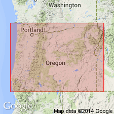
- Klamath Mountains province
Summary:
Pg. 30 (fig. 2b), 31 (fig. 3), 33 (fig. 4), 36, 45-48. Formal proposal of name. Myrtle Group of Imlay (1959, AAPG Bull., v. 43, no. 12), whose type locality is along South Umpqua River near Days Creek, consists of Upper Jurassic Riddle Formation and Lower Cretaceous Days Creek Formation. Rocks of like age in Port Orford-Gold Beach area were designated by these names. Koch (1963) recognized essential lithologic differences and renamed the coast rocks (ascending) Otter Point Formation, Humbug Mountain Conglomerate, and Rocky Point Formation. Humbug Mountain, about 3,000 feet thick, contains near its top a graded fine conglomerate as well as subordinate zones of interstratified mudstone and graded sandstone, and is distinguished from the gradationally overlying Rocky Point Formation by thick, coarse, typically massive conglomerate. Decided unlike the inland, partly correlative, nonconglomeratic Days Creek Formation type section. At the fossiliferous type section, the Humbug Mountain consists of coarse to fine conglomerate, conglomeratic sandstone, sandstone and subordinate mudstone, which includes altered, plant debris. Age is Early Cretaceous.
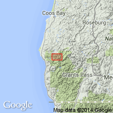
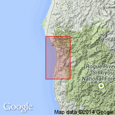
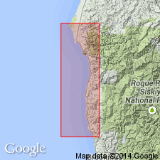
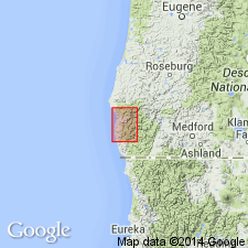
Type section: on southwestern flank of Humbug Mountain, in SE/4 sec. 35, T. 33 S., R. 15 W., Port Orford quadrangle, southwestern OR coast.
35, T. 33 S., R. 15 W., Port Orford quadrangle, southwestern Oregon
Representative section: northeast side of Humbug Mountain, SW/4 sec. 26, T. 33 S., R. 15 W., Port Orford quadrangle, southwestern OR coast.
Source: US geologic names lexicon (USGS Bull. 1350, p. 352-353).
- Usage in publication:
-
- Humbug Mountain Conglomerate*
- Modifications:
-
- Adopted
- AAPG geologic province:
-
- Oregon-Washington Coast Ranges province
Summary:
Humbug Mountain Conglomerate of Koch (1966) adopted by the USGS. Overlies Otter Point Formation. Present in southwestern Oregon. Age is Early Cretaceous.
Source: Changes in stratigraphic nomenclature, 1972 (USGS Bull. 1394-A, p. A20-A21).
- Usage in publication:
-
- Humbug Mountain Conglomerate*
- Modifications:
-
- Revised
- AAPG geologic province:
-
- Oregon-Washington Coast Ranges province
Summary:
Humbug Mountain Conglomerate assigned to Myrtle Group. Present in southwestern Oregon. Age is Early Cretaceous.
Source: Changes in stratigraphic nomenclature, 1972 (USGS Bull. 1394-A, p. A20-A21).
For more information, please contact Nancy Stamm, Geologic Names Committee Secretary.
Asterisk (*) indicates published by U.S. Geological Survey authors.
"No current usage" (†) implies that a name has been abandoned or has fallen into disuse. Former usage and, if known, replacement name given in parentheses ( ).
Slash (/) indicates name conflicts with nomenclatural guidelines (CSN, 1933; ACSN, 1961, 1970; NACSN, 1983, 2005, 2021). May be explained within brackets ([ ]).