

- Usage in publication:
-
- Huerfanito Bentonite Bed*
- Modifications:
-
- Named
- Dominant lithology:
-
- Bentonite
- AAPG geologic province:
-
- San Juan basin
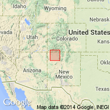
Summary:
Named as a marker bed in the upper part of the Lewis Shale for the El Paso Natural Gas Huerfanito Unit 60 in SW1/4 SW1/4 sec 4, T26N, R9W, San Juan Co, NM in the San Juan basin. The Huerfanito well is the type well. The bed lies between 2,550 and 2,562 ft about 350 ft below the top of the Lewis and is a distinctive 12 ft thick unit recognizable on induction-electric and sonic-gamma ray logs. Is more conductive than the rocks above and below it. Traceable throughout the subsurface of the San Juan basin in northwest NM and southwest CO. Bentonite resulted from an ancient volcanic ash fall into the Lewis sea. Source of ash probably from the west; the ash bed is probably thicker to the west. Has not been cored. Of Late Cretaceous age. Figures show subsurface characteristics and areal extent.
Source: GNU records (USGS DDS-6; Denver GNULEX).
For more information, please contact Nancy Stamm, Geologic Names Committee Secretary.
Asterisk (*) indicates published by U.S. Geological Survey authors.
"No current usage" (†) implies that a name has been abandoned or has fallen into disuse. Former usage and, if known, replacement name given in parentheses ( ).
Slash (/) indicates name conflicts with nomenclatural guidelines (CSN, 1933; ACSN, 1961, 1970; NACSN, 1983, 2005, 2021). May be explained within brackets ([ ]).