

- Usage in publication:
-
- Hualpai [Hualapai] limestone
- Modifications:
-
- Named
- Dominant lithology:
-
- Limestone
- AAPG geologic province:
-
- Plateau sedimentary province
Summary:
Pg. 1429-1431. Hualpai [Hualapai] limestone. Consists chiefly of white though gray to pink or light-brown limestone, in thin and rather regular beds, many of which have porous structure characteristic of travertine. Rock compact and nearly aphanitic between scattered openings. [Has a large number of branching tubes (probably plant stems). Spherical bodies of thin shells abundant in some beds; these may be algal growths or inorganic concretions.] Contains scattered pebbles and sand near base. Locally includes [some gypsum], and thin beds of shale and siltstone. Also contains gray to pink or light-brown chert nodules and lenses. Degree of porosity varies considerably from bed to bed as well as laterally in any one layer. In some parts, openings occupy full fifty percent of the volume, and rock would be described as tufa. Opening diameters range from one-half inch down to limit of visibility. In most western outcrops, thickness varies up to 150 to 200 feet. Delmar Butte and Temple, north of Colorado River are capped by 80 to 100 feet of limestone. Original maximum thickness certainly exceeded 1,000 feet. [Lies unconformably on basin deposits, landslide deposits south of the river. North of the river, it lies on fanglomerate. Upper surface is erosional. No fossils found.] Age is Pliocene(?). [Report includes measured section, cross sections. Local occurrences described.]
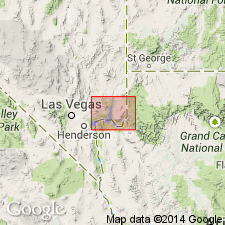
[Type locality not designated.] Displayed prominently along Hualpai [Hualapai] Wash, AZ, from which unit is named. Distributed over irregular area, measuring 25 mi east-west and comparable distance north-south, Mohave Co., AZ and Clark Co., NV (Plateau sedimentary province).
Source: US geologic names lexicon (USGS Bull. 1200, p. 1825-1826); supplemental information (in brackets) from GNU records (USGS DDS-6; Denver GNULEX).

- Usage in publication:
-
- Hualapai Limestone Member*
- Modifications:
-
- Revised
- Geochronologic dating
- AAPG geologic province:
-
- Great Basin province
- Plateau sedimentary province
Summary:
Hualapai Limestone revised to upper member of Muddy Creek Formation [reason not stated]. Exposed at base of Grand Wash Cliffs, north and south of Lake Mead, Mohave County, Arizona, and in adjoining Nye County, Nevada. Interpreted as a marine to brackish water deposit. Age is late Miocene; sample collected from an air-fall tuff within the Hualapai yielded a K-Ar age of 8.44 +/-2.2 Ma.
Source: Modified from GNU records (USGS DDS-6; Denver GNULEX).
- Usage in publication:
-
- Hualapai Limestone Member*
- Modifications:
-
- Areal extent
- Overview
- AAPG geologic province:
-
- Plateau sedimentary province
- Great Basin province
Summary:
As the upper member of the Muddy Creek Formation, is exposed as erosional remnants (map) in Lake Mead area of southeast NV and northwest AZ, and at base of Grand Wash Cliffs of northwest AZ. These areas are in the Plateau sedimentary and Great Basin provinces. Type locality designated as the best exposure along Hualapai Wash from spot where the wash joins Lake Mead south along wash for about 9 km, Mohave Co, AZ. Is 240+ m thick at its type. Areal extent of Hualapai exposures known from Black Mountains of AZ and NV on west to the Grand Wash Cliffs on the east, and south of Lake Mead from the White Hills on the west to the Cliffs. Overlies lower part of Muddy Creek. Consists of reddish, cliff-forming limestone with limy argillaceous interbeds of claystone, mudstone, and siltstone that thicken and thin over short distances. Some scattered chert nodules. Algal structures abundant locally. Gastropods, ostracods, trace fossils, diatoms, plant and leaf stem fossils. Thin gypsum beds scattered throughout. An air-fall tuff 15 cm thick in lower part of member yielded a K-Ar age of about 8.7 +/-2.2 m.y. or late Miocene; however, maximum and minimum age limits of member not known. Probably deposited in an estuary at end of embayment of the Gulf of CA which extended as far as Lake Mead.
Source: GNU records (USGS DDS-6; Denver GNULEX).
- Usage in publication:
-
- Hualapai Limestone*
- Modifications:
-
- Revised
- AAPG geologic province:
-
- Plateau sedimentary province
Summary:
Restored to formation rank. Was assigned to member rank in some earlier reports because it was interbedded with the underlying unnamed red sandstone thought to be part of the Muddy Creek Formation. In this report, the red sandstone is assigned to the Horse Spring Formation on Overton Ridge, Clark Co, NV; is unassigned to a formation east of Frenchman Mountain in the White Basin and Bitter Spring valley, Clark Co, NV, and is assigned to the Muddy Creek Formation in the area from the Virgin Mountains to the Grand Wash Cliffs, Clark Co, NV and Mohave Co, AZ. Considered to be older than 11.6 m.y. and possibly as young as 4 m.y. Nomenclature chart. Geologic maps. Mapped south of Lake Mead in Mohave Co, AZ in the Plateau sedimentary province. Occurs in Grand Wash and west to Grapevine Mesa.
Source: GNU records (USGS DDS-6; Denver GNULEX).
For more information, please contact Nancy Stamm, Geologic Names Committee Secretary.
Asterisk (*) indicates published by U.S. Geological Survey authors.
"No current usage" (†) implies that a name has been abandoned or has fallen into disuse. Former usage and, if known, replacement name given in parentheses ( ).
Slash (/) indicates name conflicts with nomenclatural guidelines (CSN, 1933; ACSN, 1961, 1970; NACSN, 1983, 2005, 2021). May be explained within brackets ([ ]).