

- Usage in publication:
-
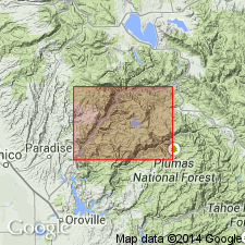
- Horseshoe Bend Formation*
- Modifications:
-
- Named
- Dominant lithology:
-
- Quartzite
- Chert
- Metavolcanics
- AAPG geologic province:
-
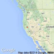
- Sierra Nevada province
Summary:
Named after Horseshoe Bend of Little North Fork. Type section designated as exposures in roadcuts along Little North Fork of Middle Fork of Feather River, secs.1, 12-13 T22N R6E, Pulga 15' quad, Plumas and Butte Cos, CA. Extends into Bucks Lake 15' quad. Consists of metabasalt, meta-andesite, metadacite, metarhyolite, marble, phyllite, quartzite, metachert, and metatuff. These various lithologies shown separately on maps of Pulga and Bucks Lake 15' quads. Is 300 m thick. Presumably overlies Duffey Dome and Franklin Canyon Formations. Underlies Jurassic and Cretaceous ultramafic and plutonic rocks. Age given as Paleozoic(?).
Source: GNU records (USGS DDS-6; Menlo GNULEX).
- Usage in publication:
-
- Horseshoe Bend Formation*
- Modifications:
-
- Age modified
- AAPG geologic province:
-
- Sierra Nevada province
Summary:
Horseshoe Bend Formation is considered to be of probable Permian(?) age. Is heterogeneous sequence of interbedded metavolcanic and metasedimentary rocks including thin layers of limestone. Can be divided into: oldest rocks of metabasalt, middle part of phyllite and quartzite, and upper part of basaltic rocks with some quartzite layers.
Source: GNU records (USGS DDS-6; Menlo GNULEX).
For more information, please contact Nancy Stamm, Geologic Names Committee Secretary.
Asterisk (*) indicates published by U.S. Geological Survey authors.
"No current usage" (†) implies that a name has been abandoned or has fallen into disuse. Former usage and, if known, replacement name given in parentheses ( ).
Slash (/) indicates name conflicts with nomenclatural guidelines (CSN, 1933; ACSN, 1961, 1970; NACSN, 1983, 2005, 2021). May be explained within brackets ([ ]).