

- Usage in publication:
-
- Hood Bay Formation*
- Modifications:
-
- Named
- Dominant lithology:
-
- Chert
- Argillite
- Graywacke
- Limestone
- AAPG geologic province:
-
- Alaska Southeastern region
Summary:
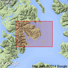
Typically exposed along two rivers flowing westward into North Arm of Hood Bay, Admiralty Island, southeastern AK. Is sequence of dark-hued carbonaceous chert, siliceous argillite, graywacke, limestone, and minor altered basic volcanic rock. Lacks distinctive persistent members and has been isoclinally folded, so that measurement of accurate stratigraphic thickness is impossible. Thickness may be few 1000 ft. Unconformably overlain by Permian Cannery Formation (new). To southwest unit is buried unconformably by Tertiary Admiralty Island Volcanics (new). To northeast is in fault contact with Cannery Formation and younger formations in complex manner along Pybus fault zone. Coeval with Gambier Bay Formation (new). Shown on geologic map of Pybus-Gambier area. Age is probably Devonian(?) based on stratigraphic relations.
Source: GNU records (USGS DDS-6; Menlo GNULEX).
- Usage in publication:
-
- Hood Bay Formation*
- Modifications:
-
- Age modified
- AAPG geologic province:
-
- Alaska Southeastern region
Summary:
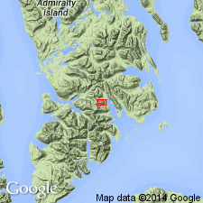
Age of Hood Bay Formation is Middle Ordovician on basis of graptolite fauna collected from northern end of Pybus Bay location as shown on portion of map of Sitka B-1 (1:63,360) quad, AK. List of graptolites included in report.
Source: GNU records (USGS DDS-6; Menlo GNULEX).
For more information, please contact Nancy Stamm, Geologic Names Committee Secretary.
Asterisk (*) indicates published by U.S. Geological Survey authors.
"No current usage" (†) implies that a name has been abandoned or has fallen into disuse. Former usage and, if known, replacement name given in parentheses ( ).
Slash (/) indicates name conflicts with nomenclatural guidelines (CSN, 1933; ACSN, 1961, 1970; NACSN, 1983, 2005, 2021). May be explained within brackets ([ ]).