The National Geologic Map Database is migrating to a new infrastructure. We apologize for any service disruptions during this process.
|
|---|


- Usage in publication:
-
- Hondo slate
- Modifications:
-
- Original reference
- Dominant lithology:
-
- Slate
- Schist
- AAPG geologic province:
-
- Southern Rocky Mountain region
Summary:
Pg. 11, 13 (table 1), 23, pl. 2. Hondo slate. Characteristically black carbonaceous slate, has well-developed schistosity. Weathers rusty color. In many places, particularly along Arroyo Hondo, the black slate grades into quartz-muscovite schist. Ranges up to a mile in thickness. Overlies Ortega quartzite (new). Age is Precambrian (Proterozoic).
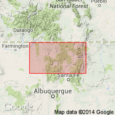
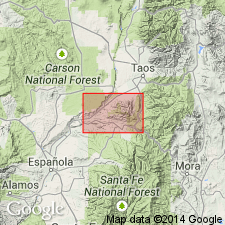
Notable exposures in [Trampas 7.5-min quadrangle, Taos Co.], central northern NM: belt extending from near Dixon northeast to central part of drainage system of Arroyo Hondo, [along Kit Carson Highway (U.S. 64), Canon del Rio Grande; smaller belt between Harding mine and Copper Hill [in secs. 20 and 29, T. 23 N., R. 11 E.]; and along Dixon-Penasco Road [Route 75] a few mi east of Dixon.
(Additional locality information from USGS historical topographic map collection TopoView, accessed June 12, 2014.)
Source: US geologic names lexicon (USGS Bull. 1200, p. 1795-1796).
- Usage in publication:
-
- Hondo slate†
- Modifications:
-
- Abandoned
Summary:
Ortega quartzite of Just (1937) redescribed, revised, and areally extended into report area, Picuris Range area, Taos and Rio Arriba Cos, NM, Southern Rocky Mountain region. Just (1937) used Ortega for quartzite exposed in Ortega Mountains, 25 mi northwest of Picuris Range. Redescribed in this report as Ortega formation, is made up of wholly metasedimentary rocks and comprises (ascending): 1) a lower, quartzite member 2,500+ ft thick (base not exposed in this area); 2) Rinconada schist member, which contains 4 mappable units--andalusite-biotite hornfels, staurolite gneiss and schist, quartzite, and muscovite-quartz-biotite-garnet phyllite--totaling 1,800 ft; and Pilar phyllite member (here named), a gray-black carbonaceous phyllite which was termed Hondo slate by Just (1937) (Hondo here abandoned--name used for other rocks prior to Just's usage), 2,300 ft thick. Total thickness of Ortega formation is 6,600 ft. Underlies the conglomerate member of Vadito formation (here named) unconformably--Vadito is at least the partial equivalent of Hopewell series of Just (1937). Name Hopewell pre-empted, and here abandoned. Lithology and distribution described in detail. Ortega formation is of pre-Cambrian age. Geologic map, cross sections, columnar section.
Source: GNU records (USGS DDS-6; Denver GNULEX).
For more information, please contact Nancy Stamm, Geologic Names Committee Secretary.
Asterisk (*) indicates published by U.S. Geological Survey authors.
"No current usage" (†) implies that a name has been abandoned or has fallen into disuse. Former usage and, if known, replacement name given in parentheses ( ).
Slash (/) indicates name conflicts with nomenclatural guidelines (CSN, 1933; ACSN, 1961, 1970; NACSN, 1983, 2005, 2021). May be explained within brackets ([ ]).