

- Usage in publication:
-
- Holokuk basalt*
- Modifications:
-
- Named
- Dominant lithology:
-
- Basalt
- AAPG geologic province:
-
- Alaska Southwestern region
Summary:
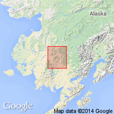
Named for Holokuk River, central Kuskokwim region, southwestern AK. Typically exposed in Kaluvarawluk and Kiokluk Mountains east of Holokuk River. Also crops out in flanks of Horn Mountains, north of Kuskokwim River. Consists of flows and less abundant water-deposited detritus made up almost exclusively of black porphyritic basalt weathering to browns and buffs. Is at least 3000 ft thick along southeast slopes of Horn Mountains and less than 1000 ft elsewhere. Unconformably overlies Kuskokwim group (new). Overlies (?) Getmuna rhyolite group (new); contact is covered. Horn Mountain stock lies between 2 belts of Holokuk basalt. Basalt underlies Quaternary glacial deposits. Age is middle Tertiary, probably from late Eocene through early Miocene. Geologic map of central Kuskokwim region shows age as Eocene(?), Oligocene(?), and Miocene(?).
Source: GNU records (USGS DDS-6; Menlo GNULEX).
For more information, please contact Nancy Stamm, Geologic Names Committee Secretary.
Asterisk (*) indicates published by U.S. Geological Survey authors.
"No current usage" (†) implies that a name has been abandoned or has fallen into disuse. Former usage and, if known, replacement name given in parentheses ( ).
Slash (/) indicates name conflicts with nomenclatural guidelines (CSN, 1933; ACSN, 1961, 1970; NACSN, 1983, 2005, 2021). May be explained within brackets ([ ]).