

- Usage in publication:
-
- Holdrege formation*
- Modifications:
-
- Original reference
Summary:
Pg. 190. Holdrege formation (Nebraskan). Lowermost gravel-sand deposit in southern Nebraska, 50 to 100+ feet thick. Conformably underlies Fullerton formation (Aftonian).
Source: US geologic names lexicon (USGS Bull. 896, p. 968-969).
- Usage in publication:
-
- Holdrege formation*
- Modifications:
-
- Principal reference
- AAPG geologic province:
-
- Salina basin
Summary:
Pg. 326, 342-344. Holdrege formation. Largely fluvial inwash-outwash deposits of sand and gravel, generally coarse near base and finer toward top. Thickness 0 to 120+/- feet. Is = Nebraskan till and David City formation, both of Nebraskan age. Not known to outcrop in Platte River Valley or south-central Nebraska. May be exposed at some places along Republican Valley. Is certainly exposed at several places in Niobrara Valley. Is known almost entirely from well logs. Underlies Fullerton formation and rests unconformably on Tertiary or Cretaceous. Occurs more or less continuously over area of 15,000+/- sq mi.
Named from the Trees deep test for oil and gas near Holdrege, Phelps Co., southern NE.
Source: US geologic names lexicon (USGS Bull. 896, p. 968-969).
- Usage in publication:
-
- Holdrege formation*
- Modifications:
-
- Areal extent
Summary:
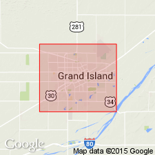
Pg. 12 (fig. 6), 17-18. Holdrege formation. Formation is coarse, gravelly to pebbly valley fill at high levels in South Platte, Lodgepole, Pumpkin Creek, and North Platte valleys where it originated from Rocky Mountain glaciers and from gravelly Tertiary deposits of High Plains. Occurs in lower course of Niobrara Valley and adjacent areas and on Holt and Springview plains; lies below flood plain of the Platte in vicinity of Grand Island and westward for some distance. [Age is Pleistocene (Nebraskan).]
Source: US geologic names lexicon (USGS Bull. 1200, p. 1780-1781).
- Usage in publication:
-
- Holdrege member
- Modifications:
-
- Revised
- Areal extent
- AAPG geologic province:
-
- Central Kansas uplift
Summary:
Pg. 64. Holdrege member of Chase Channel formation (new), a subsurface unit in western Kansas. Thickness 28 to 56 feet. Medium to fine gravel and sand with fragments of Cretaceous shells and fragments of red shale and siltstone where it overlies Permian rocks. Grades upward into Fullerton member. Age is Pleistocene (Nebraskan).
Source: US geologic names lexicon (USGS Bull. 1200, p. 1780-1781).

- Usage in publication:
-
- Holdrege member
- Modifications:
-
- Revised
Summary:
Pg. 15; J.C. Frye and A.B. Leonard, 1952, Kansas Geol. Survey Bull., no. 99, p. 52 (fig. 2), 59, 61. Holdrege member of Blanco formation in Kansas. [Age is Pleistocene (Nebraskan).]
Source: US geologic names lexicon (USGS Bull. 1200, p. 1780-1781).
- Usage in publication:
-
- Holdrege member
- Modifications:
-
- Revised
- AAPG geologic province:
-
- Anadarko basin
Summary:
Pg. 55 (fig. 1). Chart of revised classification of Kansas Pleistocene shows Holdrege as member of unnamed formation in Meade group. Occurs below Fullerton member and above Nebraska till.
Source: US geologic names lexicon (USGS Bull. 1200, p. 1780-1781).

- Usage in publication:
-
- Holdrege formation*
- Modifications:
-
- Revised
Summary:
Shown as Holdrege formation in Kansas. [Age is Pleistocene (Nebraskan).]
Source: US geologic names lexicon (USGS Bull. 1200, p. 1780-1781).
- Usage in publication:
-
- Holdrege sand and gravel member
- Modifications:
-
- Principal reference
- Revised
- AAPG geologic province:
-
- Salina basin
Summary:
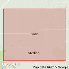
Pg. 18, 25-26; Appendix, p. 51-52. Holdrege sand and gravel member of Fullerton Formation. Grades from very fine to very coarse sand in upper 7 feet to sand and gravel (medium sand to medium gravel) in lower 55.3 feet with a thin silt separation 34.6 feet above base. Thickness 62.3 feet. Underlies upper silt member of Fullerton; overlies lower Nebraskan Seward Formation. Age is early Pleistocene (late Nebraskan). Substitute type section designated. Type Holdrege of Lugn, 1935 (Nebraska Geol. Survey Bull., no. 10, p. 92, 93) in test well for oil and gas is now believed to be part of the Ogallala Formation of Pliocene age.
Substitute type section (subsurface): ground water survey test hole A15-1-24aaa, 82 ft west and 9 ft south of northeast corner of sec. 24, T. 5 N., R. 1 E., Butler Co., southeastern NE.
Source: Publication.
For more information, please contact Nancy Stamm, Geologic Names Committee Secretary.
Asterisk (*) indicates published by U.S. Geological Survey authors.
"No current usage" (†) implies that a name has been abandoned or has fallen into disuse. Former usage and, if known, replacement name given in parentheses ( ).
Slash (/) indicates name conflicts with nomenclatural guidelines (CSN, 1933; ACSN, 1961, 1970; NACSN, 1983, 2005, 2021). May be explained within brackets ([ ]).