The National Geologic Map Database is migrating to a new infrastructure. We apologize for any service disruptions during this process.
|
|---|


- Usage in publication:
-
- Hogeye Tuff
- Modifications:
-
- Mapped
- AAPG geologic province:
-
- Permian basin
Summary:
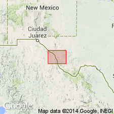
Hogeye Tuff mapped as a formation of Garren Group in the Eagle, Van Horn, and Wylie Mountains area, Culberson and Jeff Davis Cos, west TX in Permian basin. Garren Group is shown on the Correlation of Map Units as consisting of (ascending): Hogeye Tuff, Pantera Trachyte, an undivided part, and Petan Basalt. In Eagle Mountains area, southern Indio Mountains, Hogeye is composed of an upper tuff, 75 ft thick, a middle trachyte 170-250 ft thick, and lower tuff, 30 ft thick. In Van Horn Mountains, composed of an upper sandstone, 7-80 ft thick, and a lower vitric tuff with lenses of conglomerate, 180-355 ft thick. In the Wylie Mountains, composed of a tuff and tuff breccia with a basalt member near base; thickness 195 ft. [Author states that correlation of volcanic rocks from area to area on Marfa sheet is uncertain--little attempt is made to correlate between areas. The rocks are described by area.] Hogeye is of Oligocene age. Geologic map.
Source: GNU records (USGS DDS-6; Denver GNULEX).
- Usage in publication:
-
- Hogeye Tuff
- Modifications:
-
- First used
- Dominant lithology:
-
- Tuff
- AAPG geologic province:
-
- Permian basin
Summary:
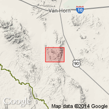
First published use. Refers to an unpublished thesis. [Theses not considered to be acceptable reports for new stratigraphic names, NASC art 4a.] Source of name and type locality not stated. Includes most of the tuffaceous sediments of the Van Horn Mountains, Culberson Co, TX in the Permian basin. Name applied to bedded, commonly zeolitic tuffaceous sediments that are exposed within and outside the Van Horn Mountains caldera. Unconformably overlies an unnamed tuff-breccia within the caldera and overlies the Buckshot Ignimbrite outside the caldera. Is a generally fine-grained, bedded tuffaceous sediment. Two facies recognized: 1) coarser grained, finely laminated lacustrine unit that is finely laminated, ripple marked, cross bedded within the caldera and near Carpenter Lodge; and 2) finer grained, thickly bedded, fluvial unit that is thinly bedded to structureless, deposited within and just northeast of the caldera. All of tuff has been diagenetically altered and is well indurated. Ranges from 12 m near Carpenter Lodge to 57 m on south face of High Lonesome Peak. Geologic map. Correlation chart. Oligocene age.
Source: GNU records (USGS DDS-6; Denver GNULEX).
For more information, please contact Nancy Stamm, Geologic Names Committee Secretary.
Asterisk (*) indicates published by U.S. Geological Survey authors.
"No current usage" (†) implies that a name has been abandoned or has fallen into disuse. Former usage and, if known, replacement name given in parentheses ( ).
Slash (/) indicates name conflicts with nomenclatural guidelines (CSN, 1933; ACSN, 1961, 1970; NACSN, 1983, 2005, 2021). May be explained within brackets ([ ]).