

- Usage in publication:
-
- Hoffner member
- Modifications:
-
- Original reference
- Dominant lithology:
-
- Shale
- Sandstone
- AAPG geologic province:
-
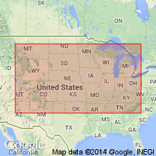
- Illinois basin
Summary:
Pg. 7, 8. Hoffner member of Ste. Genevieve limestone. Predominantly sandy shale and fine-grained sandstone that is locally massive. Associated with these strata are red shales at several horizons and in middle part of member one or more limestones. Thickness between 50 and 80 feet. Overlies Levias member; unconformably underlies Renault limestone. Age is Mississippian (Meramec).
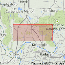
Well exposed along Swan Creek northeast of Anna in E/2 sec. 17, T. 12 S., R. 1 W., and east of Hoffner School in W/2 sec. 8, T. 13 S., R. 1 E., Union Co., southern IL.
Source: US geologic names lexicon (USGS Bull. 1200, p. 1775-1776).
- Usage in publication:
-
- Hoffner beds
- Modifications:
-
- Revised
- AAPG geologic province:
-
- Illinois basin
Summary:
Pg. 152-153, chart 5 (column 73). Hoffner beds in Ste. Genevieve limestone. Shown on correlation chart as Hoffner beds in Ste. Genevieve limestone, Meramecian series.
Source: US geologic names lexicon (USGS Bull. 1200, p. 1775-1776).
For more information, please contact Nancy Stamm, Geologic Names Committee Secretary.
Asterisk (*) indicates published by U.S. Geological Survey authors.
"No current usage" (†) implies that a name has been abandoned or has fallen into disuse. Former usage and, if known, replacement name given in parentheses ( ).
Slash (/) indicates name conflicts with nomenclatural guidelines (CSN, 1933; ACSN, 1961, 1970; NACSN, 1983, 2005, 2021). May be explained within brackets ([ ]).