

- Usage in publication:
-
- Hirz Mountain Limestone Member
- Modifications:
-
- Named
- Dominant lithology:
-
- Limestone
- AAPG geologic province:
-
- Klamath Mountains province
Summary:
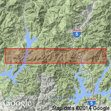
Named for series of limestone lentils cropping out in secs. 12-13 T35N R4W and sec.18 T35N R3W, Lamoine 15' and Bollibokka Mountain 15' quads, southwest slopes of Hirz Mountain Shasta Co, CA. Is member of Baird Formation. "No particular lentil is designated as type section." Consists of aphanitic blue-gray limestone with small amount of cherty and silty stringers. Beds contain variable amounts of bioclastic debris; some beds consist primarily of coral fragments. Brachiopod DIPLANUS known from Upper Pennsylvanian and Lower Permian of Texas is present. Beds are commonly 1 to 8 ft thick. Total thickness at measured section on Hirz Mountain is 70 ft.
Source: GNU records (USGS DDS-6; Menlo GNULEX).
For more information, please contact Nancy Stamm, Geologic Names Committee Secretary.
Asterisk (*) indicates published by U.S. Geological Survey authors.
"No current usage" (†) implies that a name has been abandoned or has fallen into disuse. Former usage and, if known, replacement name given in parentheses ( ).
Slash (/) indicates name conflicts with nomenclatural guidelines (CSN, 1933; ACSN, 1961, 1970; NACSN, 1983, 2005, 2021). May be explained within brackets ([ ]).