The National Geologic Map Database is migrating to a new infrastructure. We apologize for any service disruptions during this process.
|
|---|


- Usage in publication:
-
- Hills Pond peridotite*
- Modifications:
-
- Original reference
- Dominant lithology:
-
- Peridotite
- AAPG geologic province:
-
- Cherokee basin
Summary:
Hills Pond peridotite. Name proposed for a medium-grained peridotite; olive-gray when fresh, grayish-yellow when weathered. Occurs in sill-like intrusive bodies. Age is Cretaceous(?).
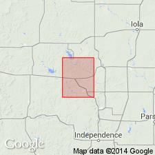
Type locality: 500 ft east and 100 ft south of center of north line of sec. 32, T. 28 S., R. 15 E., south of pond on Hill Farm in southern Belmont Twp., Woodson Co., southeastern KS.
Source: US geologic names lexicon (USGS Bull. 1200, p. 1765).
For more information, please contact Nancy Stamm, Geologic Names Committee Secretary.
Asterisk (*) indicates published by U.S. Geological Survey authors.
"No current usage" (†) implies that a name has been abandoned or has fallen into disuse. Former usage and, if known, replacement name given in parentheses ( ).
Slash (/) indicates name conflicts with nomenclatural guidelines (CSN, 1933; ACSN, 1961, 1970; NACSN, 1983, 2005, 2021). May be explained within brackets ([ ]).