

- Usage in publication:
-
- Hillery Till Member
- Modifications:
-
- Named
- Dominant lithology:
-
- Till
- Silt
- Sand
- AAPG geologic province:
-
- Illinois basin
Summary:
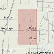
Hillery Till Member of Banner Formation here named in east-central IL. Described as reddish-brown calcareous, massive till containing silt and sand. 4.3 m thick at type section in Vermilion Co. Overlies Harmattan Till Member (new name) or Pennsylvanian bedrock; underlies Tilton Till Member (new name). Age is Kansan.
Source: GNU records (USGS DDS-6; Reston GNULEX).
- Usage in publication:
-
- Hillery Till Member
- Modifications:
-
- Revised
- AAPG geologic province:
-
- Illinois basin
Summary:
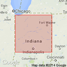
Hillery Till Member reassigned to Jessup Formation in IN. "Basic classification is based on mineralogic characteristics indicative of source provinces." Tills of the Jessup Formation were derived from a Grenville source, while tills of the Banner were derived from the Superior province. Hillery is a possible equivalent of the Cloverdale Till Member of western IN.
Source: GNU records (USGS DDS-6; Reston GNULEX).
For more information, please contact Nancy Stamm, Geologic Names Committee Secretary.
Asterisk (*) indicates published by U.S. Geological Survey authors.
"No current usage" (†) implies that a name has been abandoned or has fallen into disuse. Former usage and, if known, replacement name given in parentheses ( ).
Slash (/) indicates name conflicts with nomenclatural guidelines (CSN, 1933; ACSN, 1961, 1970; NACSN, 1983, 2005, 2021). May be explained within brackets ([ ]).