

- Usage in publication:
-
- Hidden Falls member
- Modifications:
-
- Named
- Dominant lithology:
-
- Limestone
- AAPG geologic province:
-
- Sioux uplift
Summary:
Name applied to member (of 5) in middle of the Platteville formation. Lies 10 feet 7 inches above base of Platteville. In Twin Cities area, Minnesota, composed of blue, argillaceous, dolomitic limestone, where it is about 6 feet thick; includes bentonite or bentonitic shale at top. Basal unit is a 3-inch-thick limestone transitional with underlying Mifflin member of Platteville; a wavy-bedded, thin-bedded, gray, dolomitic limestone with abundant shale partings. Upper unit is a thin, yellow-orange, bentonitic shale, underlying Magnolia member of the Platteville, which is of similar lithologic character as the Mifflin except that it has fewer shale partings. Varies in thickness from 5 feet 9 inches (at type) to 6 feet 4 inches. Thins to the east, grades into Magnolia lithology. Extends as far south as Faribault, where it is 17 inches thick, and Cannon Falls, where it is about 8 feet thick and is overlain directly by the Carimona member. Is not present at Ellsworth, Wisconsin, and not present to the south in Goodhue and Rice Counties, Minnesota, on the Iowa shelf. Hidden Falls as a deposit resulted from local tectonism in Twins City base. Age not stated.
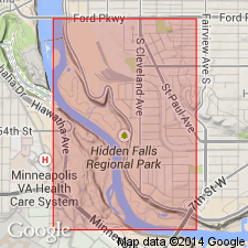
Type section is in a park named Hidden Falls, located on the Mississippi River 0.5 mi south of the Ford Motor Co. plant in St. Paul, Ramsey Co., MN, on the Sioux uplift.
Source: Modified from GNU records (USGS DDS-6; Denver GNULEX).
For more information, please contact Nancy Stamm, Geologic Names Committee Secretary.
Asterisk (*) indicates published by U.S. Geological Survey authors.
"No current usage" (†) implies that a name has been abandoned or has fallen into disuse. Former usage and, if known, replacement name given in parentheses ( ).
Slash (/) indicates name conflicts with nomenclatural guidelines (CSN, 1933; ACSN, 1961, 1970; NACSN, 1983, 2005, 2021). May be explained within brackets ([ ]).