

- Usage in publication:
-
- Hickey formation*
- Modifications:
-
- Named
- Dominant lithology:
-
- Basalt
- Gravel
- Conglomerate
- AAPG geologic province:
-
- Basin-and-Range province
Summary:
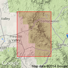
Named for mediocre exposures on Hickey Mountain, Mingus Mountain quad, Yavapai Co, AZ, Basin-and-Range province. Most typical exposures are on Mingus Mountain but name Mingus preoccupied. No type locality designated. Occurs in many scattered patches from summit of Mingus Mountain south and north in Lonesome valley. Only partial sections occur; top eroded. About 1,400 ft present on north boundary of Mingus Mountain, all but 50 ft is basalt. Is 735 ft in subsurface at Humboldt. Perched remnants in Lonesome valley suggest greater former thickness and extent. Composed of basalt flows, breccia, and basaltic sediments derived from nearby volcanic rocks that are well bedded and well sorted. Sedimentary facies consists of marl, silt, coarse gravel and conglomerate. Some of the boulders and cobbles derived from Paleozoic limestone and Precambrian siliceous rocks. Some beds and lenses are well-sorted coarse-grained sand intercalated with heterogeneous aggregate of boulders, cobbles, and pebbles also derived from Tertiary rocks. Silt and marl not described. Is younger than Supai formation and older than Verde formation (new). Tentatively assigned to Pliocene.
Source: GNU records (USGS DDS-6; Denver GNULEX).
- Usage in publication:
-
- Hickey Formation*
- Modifications:
-
- Geochronologic dating
- AAPG geologic province:
-
- Basin-and-Range province
Summary:
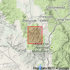
Dates of 10.1 +/-0.4 to 14.0 +/-0.6 m.y. newly reported by the K-Ar method from basalt (whole rock) in the Hickey Formation. Hickey is considered late Miocene and early Pliocene in this report area. Hickey mapped (geologic map) in the Mayer Mingus Mountain, Mount Union, Prescott, and Clarksdale quads, Yavapai Co, AZ in the Basin-and-Range province.
Source: GNU records (USGS DDS-6; Denver GNULEX).
- Usage in publication:
-
- Hickey Formation*
- Modifications:
-
- Overview
- AAPG geologic province:
-
- Basin-and-Range province
Summary:
zzzzzType section stated to be on Hickey Mountain in the Mingus Mountain quad, Yavapai Co, AZ in the Basin-and-Range province. Type section not described. Divided in mapped area or in the north-central part of the Mount Union quad into three equivalent facies--1) massive olivine basalt flows, 2) basaltic cinders, 3) boulder to pebble conglomerate. Assigned a Miocene and Pliocene age. Shown as equivalent to the Milk Creek Formation mapped in the southwest part of the quad.
Source: GNU records (USGS DDS-6; Denver GNULEX).
- Usage in publication:
-
- Hickey Formation
- Modifications:
-
- Revised
- AAPG geologic province:
-
- Basin-and-Range province
Summary:
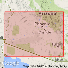
The massive salt body 1,219+ m thick, formerly referred to informally as the Luke salt body, is assigned to Luke Salt Member of Hickey Formation. The Luke occurs in the Phoenix-Tucson area, Maricopa, Pinal, Yavapai, and Yuma Cos, AZ in the Basin-and-Range province. The salt is intertongued with and underlain and overlain by unnamed parts of the Hickey. The Hickey overlies Tertiary volcanic rocks and is older than unnamed basin fill deposits. Cross sections; nomenclature chart. Miocene age.
Source: GNU records (USGS DDS-6; Denver GNULEX).
- Usage in publication:
-
- Hickey Formation*
- Modifications:
-
- Age modified
- AAPG geologic province:
-
- Basin-and-Range province
Summary:
Age of Hickey shown as Miocene only (rather than late Miocene and early Pliocene as in earlier reports). [Assignment to Miocene probably not an age change but rather an adjustment of the Miocene-Pliocene boundary from 12 m.y. to 5 m.y. The isotopic dates reported (10 to 14 or 15 m.y. K-Ar age from central AZ and 10.7 to 11.7 m.y. K-Ar age along Verde River) from Hickey were published in earlier reports.] Report area lies in the Basin-and-Range province.
Source: GNU records (USGS DDS-6; Denver GNULEX).
For more information, please contact Nancy Stamm, Geologic Names Committee Secretary.
Asterisk (*) indicates published by U.S. Geological Survey authors.
"No current usage" (†) implies that a name has been abandoned or has fallen into disuse. Former usage and, if known, replacement name given in parentheses ( ).
Slash (/) indicates name conflicts with nomenclatural guidelines (CSN, 1933; ACSN, 1961, 1970; NACSN, 1983, 2005, 2021). May be explained within brackets ([ ]).