

- Usage in publication:
-
- Heydlauff Sandstone
- Modifications:
-
- Named
- Dominant lithology:
-
- Sandstone
- Quartzite
- Limestone
- AAPG geologic province:
-
- Great Basin province
- Snake River basin
Summary:
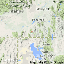
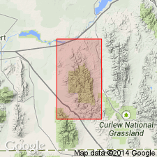
Named for exposures on ridge between Heydlauff and Saeger Canyons, east flank Sublett Range in NE1/4 secs 1 and 2, T13S, R30E (the type section), Oneida Co, ID in the Great Basin province. Extends into Power Co, ID in Snake River basin. Is a 5,000 ft thick sequence of tan or light gray sandstone interbedded with quartzite, chert, and gray sandy limestone. Limestone is most abundant near top of formation. Chert is present in three zones near middle of formation. Conformably overlies Trail Canyon Limestone (new name) and gradationally underlies Grandeur Tongue of Park City Formation. Fossils (bryozoans, crinoids, echinoid plates, sponge spicules) found in some of the limestone beds. Assigned to Leonardian part of the Early Permian. Type section measured. Graphic sections.
Source: GNU records (USGS DDS-6; Denver GNULEX).
- Usage in publication:
-
- Heydlauff Sandstone†
- Modifications:
-
- Abandoned
Summary:
Name applied to an upper Leonardian unit that overlies Trail Canyon Limestone and underlies Park City Formation in central ID abandoned. Was partly equivalent to the Hudspeth Cutoff Formation, and partly to the underlying Indian Fork Formation.
Source: GNU records (USGS DDS-6; Denver GNULEX).
For more information, please contact Nancy Stamm, Geologic Names Committee Secretary.
Asterisk (*) indicates published by U.S. Geological Survey authors.
"No current usage" (†) implies that a name has been abandoned or has fallen into disuse. Former usage and, if known, replacement name given in parentheses ( ).
Slash (/) indicates name conflicts with nomenclatural guidelines (CSN, 1933; ACSN, 1961, 1970; NACSN, 1983, 2005, 2021). May be explained within brackets ([ ]).