The National Geologic Map Database is migrating to a new infrastructure. We apologize for any service disruptions during this process.
|
|---|


- Usage in publication:
-
- Hex formation
- Modifications:
-
- Original reference
- Dominant lithology:
-
- Clay
- Shale
- Limestone
- AAPG geologic province:
-
- San Joaquin basin
Summary:
Pg. 6-8, pls. 1, 2. Hex formation. Brown and gray clay with bentonite at Hex Hill, grading westward into light-blue tuffaceous shale; abundant belemnites and some Foraminifera. Whitish, irregular limestone masses scattered throughout formation. Bedding has been destroyed by squeezing in core of Avenal Ridge piercement anticline. Because of plastic deformation, true thickness of formation cannot be determined. Contacts with other formations are everywhere discordant. Unit rests in fault contact against Badger shale, Risco formation, Serpiente sandstone, Moonlight formation, and probably Red Man sandstone (all newly named units). Fossils have been assigned tentatively to Late Jurassic.
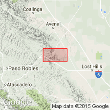
Type locality: Hex Hill, just south of Devils Den, northwestern Kern Co., southern CA. Crops out east of Orchard Peak as single band about 0.5 mi wide and more than 4 mi long, paralleling base of scarp formed by Avenal Ridge. Occupies core of Avenal Ridge piercement anticline.
Source: US geologic names lexicon (USGS Bull. 1200, p. 1749-1750).
- Usage in publication:
-
- Hex Claystone
- Modifications:
-
- Revised
- AAPG geologic province:
-
- San Joaquin basin
Summary:
Hex Formation of Marsh (1960) adopted as Hex Claystone. Its stratigraphic position is not definitely known, but it appears to be injected between underlying Gravelly Flat Formation and overlying Panoche Formation. Age is Early Cretaceous.
Source: Changes in stratigraphic nomenclature, 1973 (USGS Bull. 1395-A, p. A20-A21).
For more information, please contact Nancy Stamm, Geologic Names Committee Secretary.
Asterisk (*) indicates published by U.S. Geological Survey authors.
"No current usage" (†) implies that a name has been abandoned or has fallen into disuse. Former usage and, if known, replacement name given in parentheses ( ).
Slash (/) indicates name conflicts with nomenclatural guidelines (CSN, 1933; ACSN, 1961, 1970; NACSN, 1983, 2005, 2021). May be explained within brackets ([ ]).