The National Geologic Map Database is migrating to a new infrastructure. We apologize for any service disruptions during this process.
|
|---|


- Usage in publication:
-
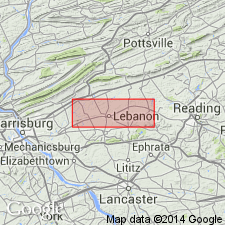
- Hershey limestone
- Modifications:
-
- Named
- Dominant lithology:
-
- Limestone
- AAPG geologic province:
-
- Appalachian basin
Summary:
Named the Hershey limestone for Hershey, Dauphin Co., southeastern PA. Consists of dark-gray, graphitic, shaly or silty limestone. Weathered exposures are typically brownish gray and show well-developed cleavage. Bedding marked by shaly laminations. Beds of conglomerate occur at base in eastern part of mapped area and contain angular to subrounded fragments of dolomite and magnesian limestone in matrix of dark-gray graphitic shaly limestone and are interbedded with normal Hershey limestone. Thickness is several hundred feet. Conglomerate zones may be more than 100 feet thick in Berks Co. Overlies Myerstown limestone and underlies Martinsburg formation. The Hershey is of Middle Ordovician age.
Source: GNU records (USGS DDS-6; Reston GNULEX).
- Usage in publication:
-
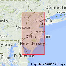
- Hershey Member
- Modifications:
-
- Revised
- AAPG geologic province:
-
- Appalachian basin
Summary:
Geographically extended the Hershey to NJ and revised it to the Hershey Member of the Jacksonburg Formation. Consists of dark-gray to black cement rock. Thickness is 600 feet. Overlies Myerstown Member of Jacksonburg and underlies Jutland Member of Martinsburg Formation.
Source: GNU records (USGS DDS-6; Reston GNULEX).
For more information, please contact Nancy Stamm, Geologic Names Committee Secretary.
Asterisk (*) indicates published by U.S. Geological Survey authors.
"No current usage" (†) implies that a name has been abandoned or has fallen into disuse. Former usage and, if known, replacement name given in parentheses ( ).
Slash (/) indicates name conflicts with nomenclatural guidelines (CSN, 1933; ACSN, 1961, 1970; NACSN, 1983, 2005, 2021). May be explained within brackets ([ ]).