The National Geologic Map Database is migrating to a new infrastructure. We apologize for any service disruptions during this process.
|
|---|


- Usage in publication:
-
- Hercules shale member*
- Modifications:
-
- Named
- Dominant lithology:
-
- Shale
- AAPG geologic province:
-
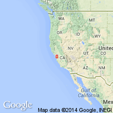
- California Coast Ranges province
Summary:
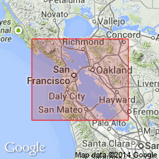
Named as member of Briones sandstone of Monterey group for Hercules Station on San Pablo Bay, Concord 15' quad, Contra Costa Co, CA. Occurs in northern part of quad. Consists of bituminous shale about 500 ft thick. Map legend gives age as Miocene.
Source: GNU records (USGS DDS-6; Menlo GNULEX).
- Usage in publication:
-
- [Hercules Shale Member*]
- Modifications:
-
- Revised
- AAPG geologic province:
-
- California Coast Ranges province
Summary:
Briones Sandstone [and its Hercules Shale Member] are part of San Pablo Group which is late Miocene in age.
Source: GNU records (USGS DDS-6; Menlo GNULEX).
For more information, please contact Nancy Stamm, Geologic Names Committee Secretary.
Asterisk (*) indicates published by U.S. Geological Survey authors.
"No current usage" (†) implies that a name has been abandoned or has fallen into disuse. Former usage and, if known, replacement name given in parentheses ( ).
Slash (/) indicates name conflicts with nomenclatural guidelines (CSN, 1933; ACSN, 1961, 1970; NACSN, 1983, 2005, 2021). May be explained within brackets ([ ]).