


- Usage in publication:
-
- Henry Formation
- Modifications:
-
- Original reference
- Dominant lithology:
-
- Sand
- Gravel
- AAPG geologic province:
-
- Illinois basin
Summary:
Pg. 70-72; Illinois Bull., no. 95, p. 226, 1975. Henry Formation. Glacial outwash of sand and gravel, and in places a few silt beds. Occurs extensively in area of Wisconsinan glaciation. Thickness varies greatly; in major valleys can be 100+ feet. Divided into: (1) Batavia Member, outwash plains, up to 30 feet; (2) Mackinaw Member, valley trains, 30 to 100+ feet; and (3) Wasco Member, ice-contact deposits. Rests on Woodfordian sediments or bedrock and is overlain by Richland or Peoria Loess, Equality Formation, or Holocene deposits. Intertongues with tills of Wedron or Winnebago Formations. Age is Pleistocene (Wisconsinan Age; Altonian Subage); locally includes deposits older than Wisconsinan.
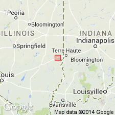
Type section [no longer exposed, ca. 1996 (see Hansel and Johnson, 1996)]: gravel pit along IL Highway 29, 2 mi (3.2 km) north of Henry, in SE/4 SE/4 sec. 32, T. 14 N., R. 10 E., Putnam Co., north-central IL. Named from village of Henry, Marshall Co., north-central IL.
Source: Publication; Hdbk Illinois stratigraphy (Illinois Geol. Survey Bull. 95, p. 226); US geologic names lexicon (USGS Bull. 1520, p. 137).
- Usage in publication:
-
- Henry Formation
- Modifications:
-
- Overview
- AAPG geologic province:
-
- Illinois basin
Summary:
Henry Formation consists of surficial sand and gravel from late Wisconsinan glaciation and thus is restricted to the North Fork Embarras River valley adjacent to the Martinsville site. A thick deposit of the Henry occurs beyond the late Wisconsinal glacial margin in the valleys of large streams and rivers. Several terraces adjacent to the Holocene floodplain are composed of this deposit. In the valley of the North Fork Embarras, the sand and gravel facies of the Cahokia Alluvium may locally correlate with the Henry. Radiocarbon ages indicate the sand and gravel is at least in part Holocene. Henry Formation has been mapped about 7 mi north along the headwaters of the North Fork Embarras River.
Source: GNU records (USGS DDS-6; Reston GNULEX).
- Usage in publication:
-
- Henry Formation*
- Modifications:
-
- Principal reference
- Revised
- AAPG geologic province:
-
- Illinois basin
- Michigan basin
- Wisconsin arch
Summary:
Pg. 6 (fig. 2), 16-18, 56-60, 100-101, 103+. Henry Formation of Mason Group. Is a discontinuous and patchy unit recognized in outcrop and subsurface of central and northern Illinois. Expanded to include the coarser grained (mostly sand and gravel) stratified sediments previously included in the Peddicord, Equality, Lake Michigan, Lemont, and Parkland formations. The finer grained (mostly silt and clay) stratified sediments are included in the Equality Formation of Mason Group. Thickness <3.3 to 213+ feet (1 to 65+ m). Occurs above Sangamon Geosol. In major river valleys, commonly underlies Cahokia Formation. Intertongues with other formations of Mason Group, notably Equality Formation, and diamicton units of Wedron Group. Correlates with part of Atherton and Martinsville Formations of Indiana. Age is Pleistocene (Wisconsinan Age; Woodfordian Subage), based on radiocarbon dating; uppermost part considered Holocene.
Principal reference sections:
(1) Beverly sand and gravel pit section, in the Beverly sand and gravel pit, about 1.5 mi (2.4 km) east of intersection of I-90 and IL Highway 25 northeast of Elgin, in sec. 31, T. 42 N., R. 9 E., Streamwood 7.5-min quadrangle, Cook Co., IL;
(2) Wedron section, in highwalls of pits in Wedron Silica Company quarries, in secs. 8, 9, 10, and 16, T. 34 N., R. 4 E., Wedron 7.5-min quadrangle, La Salle Co., IL;
(3) Charleston section, in south wall of Charleston stone quarry, approx. 500 ft (152 m) west of Embarrass River and 100 ft (30 m) north of RR tracks, in SW/4 NW/4 sec. 5, T. 12 N., R. 10 E., Ashmore 7.5-min quadrangle, Coles Co., east-central IL.
Source: Publication.
For more information, please contact Nancy Stamm, Geologic Names Committee Secretary.
Asterisk (*) indicates published by U.S. Geological Survey authors.
"No current usage" (†) implies that a name has been abandoned or has fallen into disuse. Former usage and, if known, replacement name given in parentheses ( ).
Slash (/) indicates name conflicts with nomenclatural guidelines (CSN, 1933; ACSN, 1961, 1970; NACSN, 1983, 2005, 2021). May be explained within brackets ([ ]).