- Usage in publication:
-
- Henderson Canyon Formation
- Modifications:
-
- Named
- Biostratigraphic dating
- Reference
- Dominant lithology:
-
- Limestone
- AAPG geologic province:
-
- Great Basin province
- Wasatch uplift
Summary:
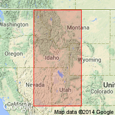
Probably named for Henderson Canyon; name replaces "Madison-Lodgepole" term. Type section in S1/2 sec 12, T16S, [R35E], Oneida Co, ID, or Lodgepole measured section (Beus, 1968). Primary reference section (Holland, 1952) in Leatham Hollow, Cache Co, UT [not described], including Madison from interval 122.5 to 881 ft. Occurs throughout southeastern ID and northeastern UT, from south of Snake River plain to north of Causey Reservoir in Wasatch Mountains, Great Basin province and Wasatch uplift. Massive cliff-slope and cliff-forming, very fine to coarse grained, dense, gray limestone [Beus' description]. Divided into 3 new members (ascending)--Chinese Wall, Brush Canyon, Devil Creek. Weathers light to medium gray; thin-bedded; contains abundant black chert as nodules, beds, and discontinuous nodular bands. Thickness greatest (241.5 m) at Causey Reservoir. Thins east and northwest from Bear River Range. In Samaria Mountains is conformably overlain by Monroe Canyon Formation; at Wellsville Mountain conformably overlain by Deseret Limestone. Contains brachiopods, corals, foraminifers, conodonts, crinoids (listed). Ranges from LOWER SIPHONODELLA CRENULATA to GNATHODUS TYPICUS conodont zones, IB, IC, IIA, IIB coral zones, pre-7, 7 and 8 Foraminifera zone, and LEPTAGONIA to SPIRIFER GRIMESI LOGANI brachiopod zone. Correlation chart. Kinderhookian and early Osagean, Early Mississippian age. Includes outer shelf, foreslope, and basin margin deposits.
Source: GNU records (USGS DDS-6; Denver GNULEX).
For more information, please contact Nancy Stamm, Geologic Names Committee Secretary.
Asterisk (*) indicates published by U.S. Geological Survey authors.
"No current usage" (†) implies that a name has been abandoned or has fallen into disuse. Former usage and, if known, replacement name given in parentheses ( ).
Slash (/) indicates name conflicts with nomenclatural guidelines (CSN, 1933; ACSN, 1961, 1970; NACSN, 1983, 2005, 2021). May be explained within brackets ([ ]).

