

- Usage in publication:
-
- Hells Gate rhyolite
- Modifications:
-
- Original reference
- AAPG geologic province:
-
- Basin-and-Range province
Summary:
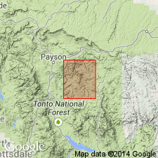
Pg. 1498 (table 1), 1506. Hells Gate rhyolite. Recrystallized rhyolite tuff. Some of rock is intrusive, as for example south of Tonto Creek it intrudes Houden formation (new) on large scale. But large parts, as northwest of Hell's Gate, display columnar structure, and some specimens display pyroclastic texture. Thickness more than 10,000 feet. No direct evidence for stratigraphic position of columnar rhyolite, but it probably belongs high in stratigraphic column of Precambrian rocks. Name given on table as Hells Gate rhyolite but unit described in text as rhyolite of the Hell's Gate area. Age is Precambrian.
Covers area 25 to 50 sq mi between Lost Camp Mountain and granite of the Payson area. Exposed northeast of Hell's Gate, Diamond Butte quadrangle, east-central AZ.
Source: US geologic names lexicon (USGS Bull. 1200, p. 1727-1728).
For more information, please contact Nancy Stamm, Geologic Names Committee Secretary.
Asterisk (*) indicates published by U.S. Geological Survey authors.
"No current usage" (†) implies that a name has been abandoned or has fallen into disuse. Former usage and, if known, replacement name given in parentheses ( ).
Slash (/) indicates name conflicts with nomenclatural guidelines (CSN, 1933; ACSN, 1961, 1970; NACSN, 1983, 2005, 2021). May be explained within brackets ([ ]).