The National Geologic Map Database is migrating to a new infrastructure. We apologize for any service disruptions during this process.
|
|---|


- Usage in publication:
-
- Hells Bells Canyon Formation
- Modifications:
-
- Named
- Dominant lithology:
-
- Conglomerate
- Ignimbrite
- Tuff
- Limestone
- AAPG geologic province:
-
- Great Basin province
Summary:
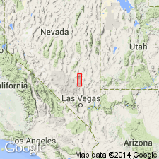
Named for Hells Bells Canyon. Type section designated as north-central part of T7S R60E about 5 mi northwest of Alamo, Lincoln Co, NV. Shown on sketch map as lower of 4 formations in Pahranagat area volcanic sequence consisting of over 3000 ft of widespread distinctive rhyodacite ignimbrites interbedded with Miocene sedimentary rocks. Entire section rests with angular unconformity on Paleozoic rocks. Hells Bells Canyon Formation is most varied of formations in composition and thickness. Can be divided into 6 lithologic subunits of unequal distribution and thickness: conglomerate, basal ignimbrite, water-laid tuff, limestone, welded tuffs, and semiconsolidated tuffs. Is from 800 to 1000 ft thick. Conformably underlies Hiko Tuff (new) of volcanic sequence. Age is Oligocene(?) to Miocene based on meager fossil evidence from limestone and correlation with other formations.
Source: GNU records (USGS DDS-6; Menlo GNULEX).
For more information, please contact Nancy Stamm, Geologic Names Committee Secretary.
Asterisk (*) indicates published by U.S. Geological Survey authors.
"No current usage" (†) implies that a name has been abandoned or has fallen into disuse. Former usage and, if known, replacement name given in parentheses ( ).
Slash (/) indicates name conflicts with nomenclatural guidelines (CSN, 1933; ACSN, 1961, 1970; NACSN, 1983, 2005, 2021). May be explained within brackets ([ ]).