The National Geologic Map Database is migrating to a new infrastructure. We apologize for any service disruptions during this process.
|
|---|


- Usage in publication:
-
- Helen Group*
- Modifications:
-
- Original reference
- Adopted
- Dominant lithology:
-
- Schist
- Gneiss
- AAPG geologic province:
-
- Piedmont-Blue Ridge province
Summary:
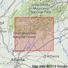
Helen Group. Used informally by Gillon, 1982 (Stratigraphic, structural, and metamorphic geology of portions of the Cowrock and Helen 7.5-min quadrangles, Athens, GA, University of Georgia, MS thesis, 236 p.), is here adopted for metamorphic rocks of the Helen thrust sheet between the Dahlonega and Shope Fork faults, Georgia and North Carolina. Includes the Nacoochee (new name), Horton (new name) (= Gillon's informal Chattahoochee), and Robertstown (new name) (= Gillon's informal Unicoi Park) Formations. The Group is fault bounded and isoclinally folded. The nature of the contact with the overlying Coweeta Group is uncertain. Age is tentatively Late Proterozoic and early Paleozoic.
Type locality: exposures near the town of Helen, Helen 7.5-min quadrangle, White Co., GA (Gillon, 1982).
Source: US geologic names lexicon (USGS Bull. 1565, p. 127).
For more information, please contact Nancy Stamm, Geologic Names Committee Secretary.
Asterisk (*) indicates published by U.S. Geological Survey authors.
"No current usage" (†) implies that a name has been abandoned or has fallen into disuse. Former usage and, if known, replacement name given in parentheses ( ).
Slash (/) indicates name conflicts with nomenclatural guidelines (CSN, 1933; ACSN, 1961, 1970; NACSN, 1983, 2005, 2021). May be explained within brackets ([ ]).