

- Usage in publication:
-
- Hedges shale*
- Modifications:
-
- Named
- Dominant lithology:
-
- Shale
- Coal
- AAPG geologic province:
-
- Appalachian basin
Summary:
Dark-gray to black carbonaceous shale containing thin seams of anthracite coal here named Hedges shale for occurrence on Hedges Mountain in east-central WV and assigned to Pocono group. Thickness at type is 170 ft (52 m). Underlies Myers shale and overlies Purslane sandstone, both also of Pocono group.
Source: GNU records (USGS DDS-6; Reston GNULEX).
- Usage in publication:
-
- Hedges Shale
- Modifications:
-
- Revised
- AAPG geologic province:
-
- Appalachian basin
Summary:
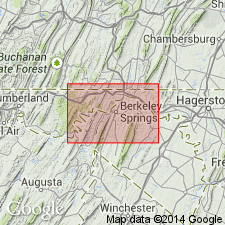
Hedges Shale removed from Pocono Group as Pocono is abandoned in WV. Rockwell, Purslane, and Hedges contain distinctive enough lithologies to be recognized as separate formations. Hedges is exposed only in Meadow Branch syncline of Morgan and Berkeley Cos., WV.
Source: GNU records (USGS DDS-6; Reston GNULEX).

- Usage in publication:
-
- Hedges Shale
- Modifications:
-
- Overview
- AAPG geologic province:
-
- Appalachian basin
Summary:
The Meadow Branch synclinorium, Berkeley Co., WV, is composed of five formations: Rockwell, Purslane, Hedges, Myers, and Pinkerton, for many years assigned to the Pocono Group. The three basal units are retained as Early Mississippian (Kinderhookian and Osagean), while the Myers and Pinkerton are now considered Late Mississippian (Meramecian). The Hedges is poorly exposed, but is estimated to be 58 m thick. Described as primarily a gray shale with approximately 25 percent sandstone. Contains thin, semi-anthracite coal beds, none of which have proved to be of any economic value. The Hedges Shale and overlying Little Mountain member (new informal name) of the Myers Shale are not known to occur outside the Meadow Branch synclinorium.
Source: GNU records (USGS DDS-6; Reston GNULEX).
For more information, please contact Nancy Stamm, Geologic Names Committee Secretary.
Asterisk (*) indicates published by U.S. Geological Survey authors.
"No current usage" (†) implies that a name has been abandoned or has fallen into disuse. Former usage and, if known, replacement name given in parentheses ( ).
Slash (/) indicates name conflicts with nomenclatural guidelines (CSN, 1933; ACSN, 1961, 1970; NACSN, 1983, 2005, 2021). May be explained within brackets ([ ]).